
Lac de l'Etroit
A series of ambient settings unfold surrounded by their own little worlds, each with its own flora, fauna and history, providing the visitor with a sense of variety in their journey.
Description
From Pont Baudin car park, go back up the Allée des Mélèzes. At the end turn right in the direction of Lac de l’Etroit. Cross the site of the Palais de la Mine. Stay well to the side, do not follow the trails that go up and down on both sides. At the end, follow ""Lac de l’Etroit"" and enter the spruce forest. Continue following these signs to the lake in question. Climb to the upper limit of the softwood forest, cross a forest of green alders, then arrive at the Alp d´Arc with the Grandes Baraques (large barracks). Follow the path that climbs the crest of the Arc mountain before descending to Lac de l’Etroit. The return route follows the trail that descends to the north, on the right. Upon arriving at a forest track, turn right and continue to Pont Baudin.
"- Departure : Pont Baudin car park, Peisey-Nancroix
- Arrival : Pont Baudin car park, Peisey-Nancroix
- Towns crossed : PEISEY-NANCROIX
Forecast
Altimetric profile
Recommandations
The descent path is steep. Once at the lake, it is advisable for people with sensitive knees to retrace their steps.
Information desks
Refuge de Rosuel, 73210 Peisey-Nancroix
Maison de Peisey, 73210 Peisey-Vallandry
Access and parking
From Route N90 road, take Route D87 in the direction of Landry, continue on this road, cross Landry, Peisey, Moulin, Nancroix, then arrive at Pont Baudin. Park in the car park at the bottom on your right where the road makes a bend
Parking :
Route planner
Accessibility
More information
8 points of interest
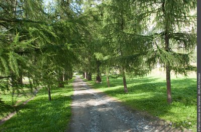
Allée de mélèzes conduisant au Palais de la Mine - Christian BALAIS  History
The Palais de la Mine and the Larch Alley
A historical site illustrating the municipality’s mining past. Discovered in 1644, the seam of galena (silver lead sulphide) was exploited up until 1866. An alley of larches leads to the former Ecole Française des Mines, which was headquartered there from 1802 to 1814. The saw marks on its trees date back to 1891/1892. They testify to an act of vengeance by people convicted of illegal logging.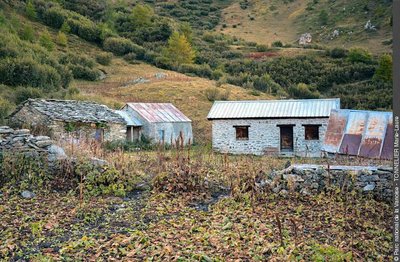
Bergerie des grandes baraques - admin  Pastoralism
The sheep pens of the large huts and the Alpage de la Montagne de l’Arc
Until the 1980s, the pasture was dairy. The two covered markets intended to house the animals are still visible. This mountain was once a “mutual venture”. Several herds were gathered and managed at a community level. A team was in charge of caring for the herd, milking and making cheese on the mountain pastures. Some non-dairy cows still graze on the pastures today but are no longer watched over.
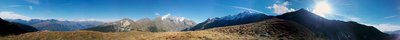
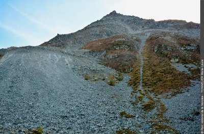
360 depuis la crête de la montagne de l'Arc - admin  Viewpoint
A 360 ° view from the crest of the Montagne de l'Arc
At the end of the ascent, stop to admire the view! To the north-west you can see the Pierra Menta (2,714 m), with its enormous square spur. To the north, the Italian slope of Mont Blanc (4,809 m). On the opposite side of the Ponturin valley are the Aiguille Grive (2,732 m), the Aiguille Rouge (3,227 m) and Mount Pourri (3,423 m). And on your slope you will see Alliet (3,109 m), the entire north face of Bellecôte (3,417 m) and the Pointe de Friolin (2,678 m).
Pointe du Friolin - Marie-Laure TONNELIER  Geology
The Pointe du Friolin and its rugged face
Between 1982 and 1984, the fall of a whole face of the Friolin mountain mobilised 10 million cubic metres, two thirds of which fell in a few months. The municipality was then forced to follow up with the support of geologists. Their studies showed that this collapse stemmed from the presence of soluble underground rocks: the anhydrous calcium sulphate crystal, also known as anhydrite, which forms gypsum by rehydration when cropped out at the surface.
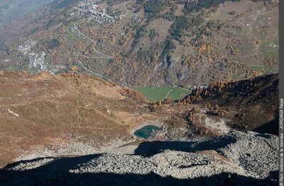
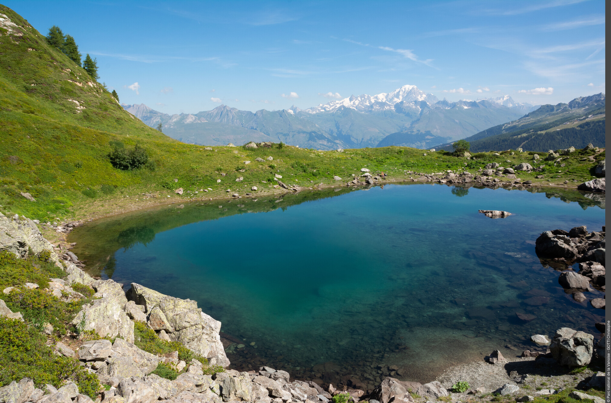
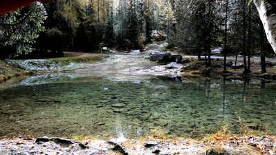
Lac de l'Etroit surplombant la vallée de Peisey-Nancroix. A g., le chef-lieu de Peisey et plus haut, la station de Plan Peisey. - Regis JORDANA  Lake
LakeLac de l'Etroit
As a reward for your efforts, this charming turquoise lake is unveiled only after the climb. It owes its origin to a depression dug out by a glacier as well as to the moraine deposits generated by their retreat. Numerous rocky boulders make this place an ideal location for a lunch break (but don’t forget to take your rubbish with you).
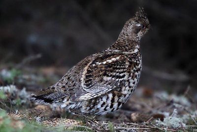
Gélinotte des Bois © Michael Haeckel - Michael Haeckel  Fauna
FaunaThe hazel grouse
The Hazel grouse is a rare galliform in Vanoise. This species is particularly fond of the mixed forests of Peisey-Nancroix on the mountain zone. It keeps a very low profile, including from a vocal point of view, the male emitting small high-pitched whistles. The hazel grouse is sedentary. To overcome the harshness of the winter climate and avoid the cold, it sinks into the snow just like the Rock Ptarmigan or the Black-tailed Grouse.
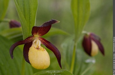
Fleur de Sabot-de-Venus. - Mylène HERRMANN  Flora
FloraLady’s slipper orchids
This wild orchid is protected at national level. It flowers in the undergrowth of Peisey in some restricted zones. The evocative shape and delicacy of its flowers earned this plant the name Lady’s slipper orchids. Although there are forty species of this kind in the world, it is the sole species existing in Europe.
Lieu Dit Eau Salée - aptv_redac  Water
WaterThe locality of “L'eau salée”
L'eau salée (Saltwater) owes its name to the many minerals contained in the water there, which passed its name on to the locality itself.
This little corner of paradise is an ideal spot for family outings: there is a little pond for the kids to enjoy and a selection of games on hand to keep them amused while the grown-ups play tennis or simply relax in the shade of the spruce forest, lulled by the lapping of the water.