
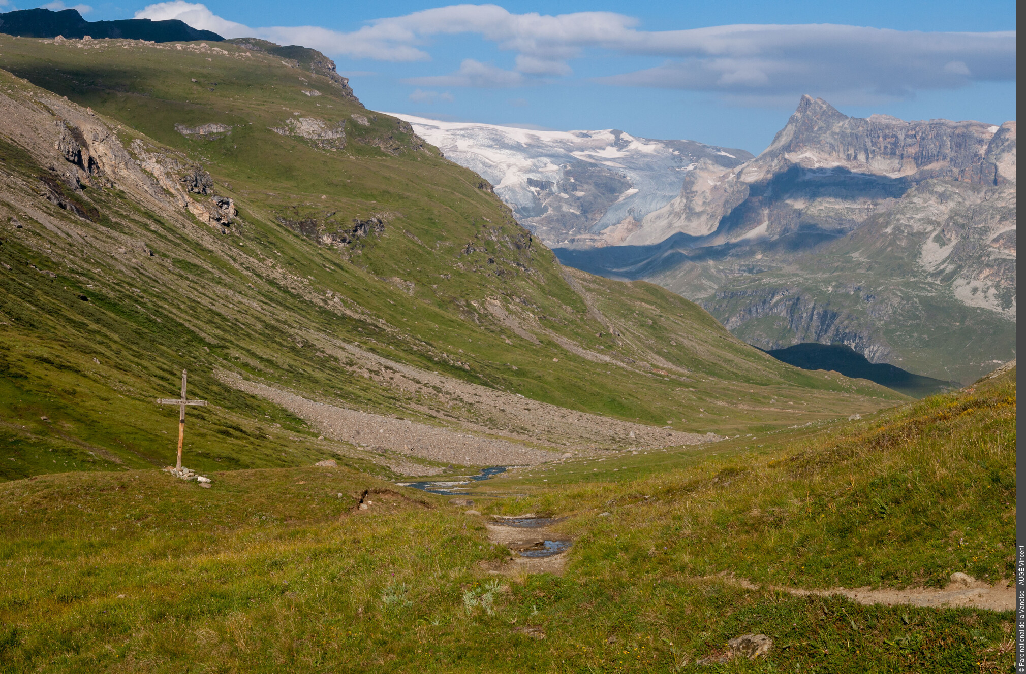
Vallon de La Rocheure
VAL-CENIS
Vallon de La Rocheure
Easy
6h30
22,1km
+704m
-704m
Return
Embed this item to access it offline
“What a surprise to discover the alpine pastures in this lost valley, steeped in history and the endeavours of farmers across time. Human presence is implicit, nature is omnipresent, not mastered but humbly tamed by generations of mountain dwellers.” Jean-Luc Étiévant, Vanoise National Park ranger
Description
From Bellecombe car park (2,307 m in altitude), head in the direction of the Refuges of Plan du Lac and Femma. Go along the Lac de Plan du Lac (2,365 m in altitude) before arriving at the refuge of the same name. Take the trail leading north-east in the direction of the Refuge de la Femma. This path crosses a rock glacier then turns east at the Trou du Chaudron. A downward crossing leads to the bottom of the valley, at the junction with the vehicle track of La Rocheure. (2,180 m in altitude). Follow the path to the east, pass in front of the chapel of Saint-Jacques and cross the bridge over the Doron before arriving at the Chalet de La Rocheure (2,250 m in altitude). At the chalet, the track stops and turns into an easy path to the Refuge de La Femma (2,352 m), destination of the route. The return journey follows the same path with a possible variation.
- Departure : Bellecombe car park, Termignon
- Arrival : Bellecombe car park, Termignon
- Towns crossed : VAL-CENIS
Forecast
Altimetric profile
Recommandations
Is in the midst of the park
The national park is an unrestricted natural area but subjected to regulations which must be known by all visitors.
Information desks
Maison de la Vanoise, Place de la Vanoise, Termignon, 73500 Val-Cenis
Vanoise Information Desk - Termignon
Place Vanoise, 73500 Termignon
Public transportation
"
Rail connection to Modane. Information: www.voyages-sncf.com
Then transport by coach to the administrative centre of Termignon. Information: www.transavoie.com
Then free shuttle bus Termignon-Bellecombe, from July to August and the weekends from 15th June to 14th September.
Shuttle bus information: www.termignon.haute-maurienne-vanoise.com/pratique/se-deplacer-sans-voiture
Suggested hitchhiking organised in the Haute-Maurienne valley. Information: www.rezopouce.fr
"Access and parking
From Termignon, head in the direction of Lanslebourg. Go on for about 500 m, then at the hairpin bend,
cross the main road and head in the direction of Bellecombe car park.
Parking :
In summer, park at Termignon, then take the free shuttle bus to Bellecombe. In the off season, park at Bellecombe car park.
Route planner
Accessibility
Traffic licence to the Refuge-Porte de Plan du Lac to be requested at the National Park for those with disabilities. Disabled car park spaces available at the refuge.
- Emergency number :
- 114
More information
6 points of interest
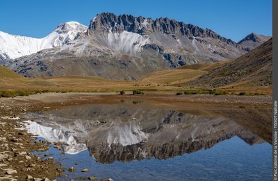
Plan du Lac - Nathalie TISSOT  Lake
LakeThe Plan du Lac
The Plan du Lac is a grassland lake. The banks are alive with rushes and sedges. The bottom is lined with stoneworts, edged by some broad-leaved pondweed. The lake is stocked with brown trout and schools of minnows wander here and there. It’s a good breeding ground for the common frog. The permeability of the limestone substratum leads to a significant drop in the water level at the end of the season.
 Pastoralism
At Plan du Lac
The pastoral road which passes in front of the Refuge de Plan du Lac serves the various alpine pastures where the farmers graze their herds of cows and sheep. This is where Beaufort, Tome de Savoie and Bleu de Termignon are made. This road is an old communication and trade route between the valleys of Tarentaise and Maurienne, via the Col de la Vanoise that links Pralognan-la-Vanoise to Termignon. It’s the “salt and cheese road”.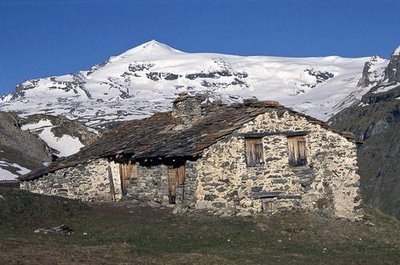
Le hameau de Pensamen (au N du Plan du Lac), façades SE (à g.) et NE (à dr.). Vue vers le Dôme de Chasseforêt. - PNV - GOTTI Christophe  Glacier
The Vanoise Glaciers
Between the Dent Parrachée (3,697 m in altitude) and the Pointe de La Réchasse (3,212 m in altitude) this glacial icecap complex extends across approximately 13 km. From the Refuge-Porte de Plan du Lac, with Chasseforêt, Pelve, Arpont ... A full-scale lesson in glaciology is on offer with various glacial forms, moraines and tracks of disappeared glaciers. The tour of the glaciers can be done in 4 to 6 days over marked trails with stopping points at the refuges.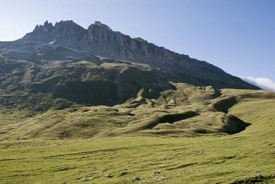
Glacier rocheux sous les Rochers de Lanserlia (au fd.). - PNV - TISSOT Nathalie  Geology
The rocky glacier of Lanserlia
The rocky glaciers are original and spectacular forms in high altitude and latitude landscapes. They are large-scale rocky debris tongues (in the order of several tens to hundreds of thousands of square metres), with fast, viscous flows spread on the slopes, moving under the influence of the inner ice. For half a century, they have generated numerous investigations and debates that have widely affected the dynamics of mountain slopes and the environmental variations in cold environments.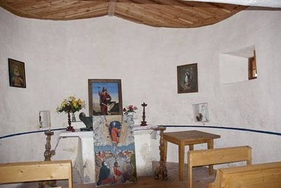
Intérieur de la Chapelle Saint Jacques. Commune de Termignon. - PNV - TISSOT Nathalie  Small heritage
The Chapel of Saint-Jacques
Founded in the 17th century and restored in 1985 and 1997, the chapel of Saint-Jacques is a reminder of just how important religion was in these harsh and remote places. To make a visit here, Irène Rosaz is the person to ask for the keys. Her alpine pasture of Pierre Blanche is the closest to the chapel. It is accessible by a track that crosses the Doron de La Rocheure.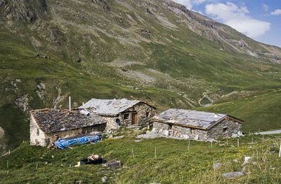
Chalets de Balme Froide, Termignon. Au fd. à dr., le Vallon de la Rocheure. - PNV - TISSOT Nathalie PastoralismThe alpine pastures of La Rocheure
Inaccessible in winter and at more than 15 km from Termignon in summer, the Rocheure valley has long been farmed thanks to its quality alpine pastures. Dairy cattle for the manufacture of Beaufort, Tomme and Bleu de Termignon and small flocks of ewes for meat, the farms are primarily family-run and occupied between 15th June and early October. For the keen observer, traces of human existence over time are everywhere from alpine pasture chalets, barns, hay meadows, chapels, to engraved stones.