
Lac du Génépy
AUSSOIS
Lac du Génépy
Challenging
6h30
14,3km
+915m
-918m
Loop
Embed this item to access it offline
The date on the calendar indicated the 14th July on this morning... There is not a ripple of water on the Génépy lake despite the gusting northerly winds. This is because a thick layer of ice covers the lake. The varying colours of the mineral world around me transect the swirls of fresh snow. This is where you go up to the Lac du Génépy, starting out from the forest in your short sleeves until you end up thinking you’re crossing the rocky stretches of Iceland, where the plants have adapted in mad-cap fashion to cling to these rocky mounds. Here the birds no longer sing, only the ringing sounds of the alpine choughs and the guttural sounds of the ptarmigan resonate. Mathieu Beurier – National Park Ranger
Description
"From the car park, follow the route of the Refuge de la Dent Parrachée. Behind it, the trail is indicated by the National Park’s yellow signs.Follow the direction for ""Lac du Génépy"". After about 30 minutes, cross the footbridge and continue the trail to the lake. To return, follow the same path. Just before the Refuge de la Dent Parrachée, turn right towards the Fond d´Aussois. Be careful, after 300 m, a short passage requires vigilance. Follow the trail to a footbridge that you leave on its right and continue south to the GR5 intersection. Then turn right and go down to the bridge you have to cross, follow the direction for Aussois until the Plan d´Amont dam from where you reach the car park."
- Departure : Dam site, village of Aussois
- Arrival : Dam site, village of Aussois
- Towns crossed : AUSSOIS
Forecast
Altimetric profile
Recommandations
High mountain route to be prepared in advance. Make sure you have the appropriate equipment and footwear and an IGN map for navigating. The weather in the mountains can change very quickly and you should turn around if it is bad.
Is in the midst of the park
The national park is an unrestricted natural area but subjected to regulations which must be known by all visitors.
Information desks
Maison Cantonale, 9 Place Sommeiller, 73500 Modane
Public transportation
"
Rail connection to Modane. Information: www.voyages-sncf.com
Then transport by coach to the administrative centre of Aussois. Information: www.transavoie.com
No public transport between Aussois and the dam site.
Suggested hitchhiking organised in the Haute-Maurienne valley. Information: www.rezopouce.fr
"Access and parking
In Modane, take the D 215 towards Aussois. Once you’ve arrived in Aussois, go to the top of the village and take the small road that rises towards the dams. Leave a panoramic viewpoint on the left and take a steep road on the right for 100 m to reach the car park.
Parking :
Car park provided by the municipality for the entire dam site, departure point for all hikes.
Route planner
Accessibility
The terminal car park is equipped with amenities but is not beyond the trail described in this record.
- Emergency number :
- 114
10 points of interest
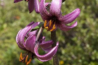
Lis martagon. - PNV - AUGÉ Vincent  Flora
FloraThe lilium martagon
In June to July when you leave the forest and set foot on the mountain pastures, you may find a large plant with purple flowers. The lilium martagon, a rare species, colonises the clearings of the forest boundary. It favours so-called mespophilic meadows that are neither too dry or too moist. This plant, once picked, was threatened. It is now out of danger but will require, like other species, much respect on your part.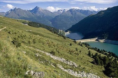
Colonisation du milieu par des pins cembro. - PNV - DARINOT Fabrice  Pastoralism
Agricultural decline
Ÿou will notice on both sides of the trail, towards the Randolière, numerous small cembro pines, established in the middle of the pastures. Whereas the entire slope was once grazed and mown, the gradual disappearance of small farm holdings and the change in practices have encouraged this forest species to recolonise the area. Over time, if agriculture were to disappear, it’s in the forest that you would find yourself. The loss of these pasture lands will lead to a decline in biodiversity.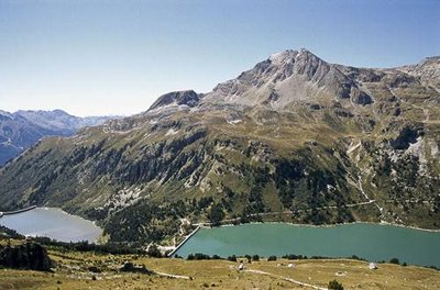
Au 1er pl., l'alpage de Plan Sec et l'alpage de la Randolière. - PNV - LACOSSE Pierre  Viewpoint
Lakes of the Aussois dam
Downhill behind you, you will be able to see the lakes of the Aussois dams. The Plan d’Amont is remarkable for its turquoise colour, fed only by the melting snows and clear streams. Downstream, the Vanoise glaciers feed the lake thanks to 19 km of underground tunnels originating from the Doron de Termignon. The water is loaded with glacial “flour”, fine mineral particles torn from the mountains. This is what gives the Plan d’Aval its grey, milky colour.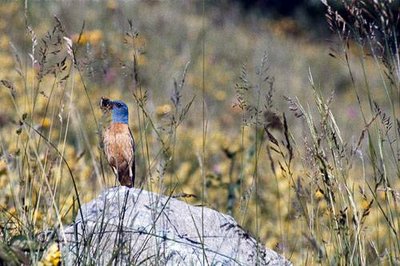
Merle de roche posé sur une pierre, ayant capturé un insecte. - PNV  Fauna
FaunaThe common rock thrush
This colourful bird did not escape from a garden centre. Despite spending its winter in Sub-Saharan Africa, the common rock thrush regularly inhabits the dry rocky and sunny slopes of our mountains to breed. While it can feed on small lizards and seeds or fruit, it gains most benefit from the abundance of various insects. At the end of summer, it will return to its wintering areas. The common rock thrush has been on the decline in France for several years with about 1,500 breeding pairs left only in France. It is a spectacle to see, so keep a keen eye.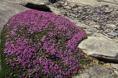
Silène acaule sur le Plateau de la Réchasse. - PNV - FOLLIET Patrick FloraThe Silene acaulis
This cushion, punctuated by bright pink flowers, is not a moss. The silene acaulis is one of the champions of adapting to the worst. The cushion-like form allows it to reduce day-time and night-time temperature variations that can be significant at these altitudes. Moisture will also be trapped in this hairy, small-leaved stem. The ancient decomposed leaves of the silène acaulis contain nutrients that will allow it to grow and to bloom. A taproot in the cushion’s core will allow it to cling to the steepest terrain.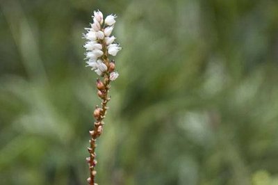
Renouée vivipare. (RN du Plan de Tuéda). - PNV - STORCK Frantz FloraPersicaria vivipara
In the midst of the sand and rock, a stem loaded with small white flowers appears. The persicaria vivipara grows here. Some plants germinate and develop in the fruit while the latter is still attached to the stock plant. This phenomenon corresponds to vegetative viviparity. If you examine the persicaria vivipara, you will see small green bulbs attached to the stem. The fruits of the persicaria vivipara then begin to germinate on the plant. The seeds of the persicaria vivipara are a delicacy for the rock ptarmigan.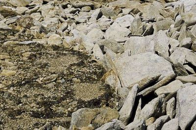
Éléments minéraux organisés en sols polygonaux sous l'action du gel et du regel. - PNV - LACOSSE Pierre  Geology
Snowy paving
Look around you for flat, damp areas without vegetation. Ÿou are bound to notice that the rock slabs seem to have been sorted and patiently arranged, one against the other. Man is not responsible for this geometric pattern. Here, the alternating freezing and thawing cycles and the weight of the snow encourage the transport of stones and their alignment to create what we call snowy paving. In other cases, these phenomena may create polygonal grounds or stone circles.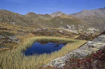
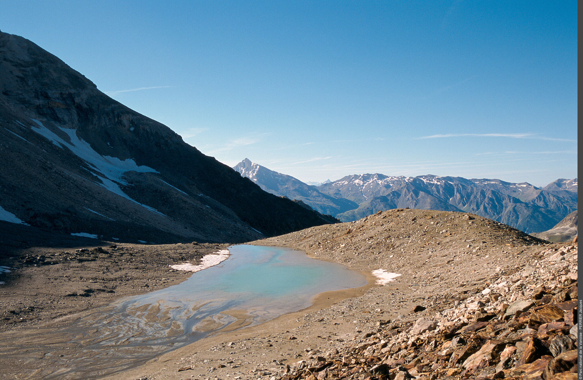
Plan d'eau en voie de comblement. Vue vers la Pointe de Lanserlia. - PNV - PERRIER Jacques GeologyThe filling of wetlands
As you descend from the lake, you will notice the grassy and flat stretches of terrain. The ancient glacier has gouged out depressions in the bedrock. When the ice retreated, these areas became lakes. Just like the Lac du Génépy, alluvium has filled these depressions, the hygrophilous vegetation then colonised these wetlands. Some of these areas then dried up to become small grassy plateaus amid the ´rocky ground´.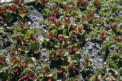
Saule herbacé. - PNV - BALAIS Christian FloraThe dwarf willow
Perhaps you have unintentionally trampled over its small, green and shiny oval leaves? Like Gargantua, you were walking over a forest! The dwarf willow (Salix herbacea) is the smallest tree in the world. Like other willows, its flowers will come together in catkins and cover the rocks with a fine cottony layer in July and August. The male and female flowers are on separate plants.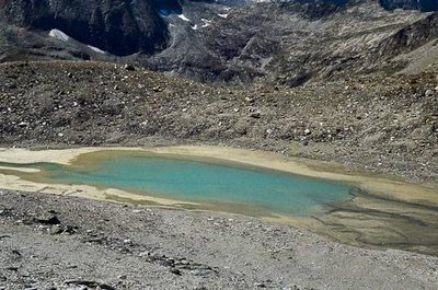
Lac du Génépy en voie d'atterrissement. - PNV - MOLLARD Maurice GeologyThe Lac du Génépy and its moraine
If you think you will discover a clear expanse of water when you arrive at the lake, you will be surprised. The Lac du Génépy is a glacial lake. At the end of the little ice age (1550-1850) the Labby glacier left a moraine on the right bank of the lake. A moraine is an accumulation of stones transported along the front of the glacier and left in place during its retreat. The glacier gouges out the rock in front of the moraine. The glacial meltwater occurs in this basin, creating the Lac du Génépy. The very fine mineral particles that you can touch on the shores of the lake fill it gradually and give it its milky colour.