
2-From typical villages to the mountain pasture of Plan Lombardie
Woodland trail : 10 km
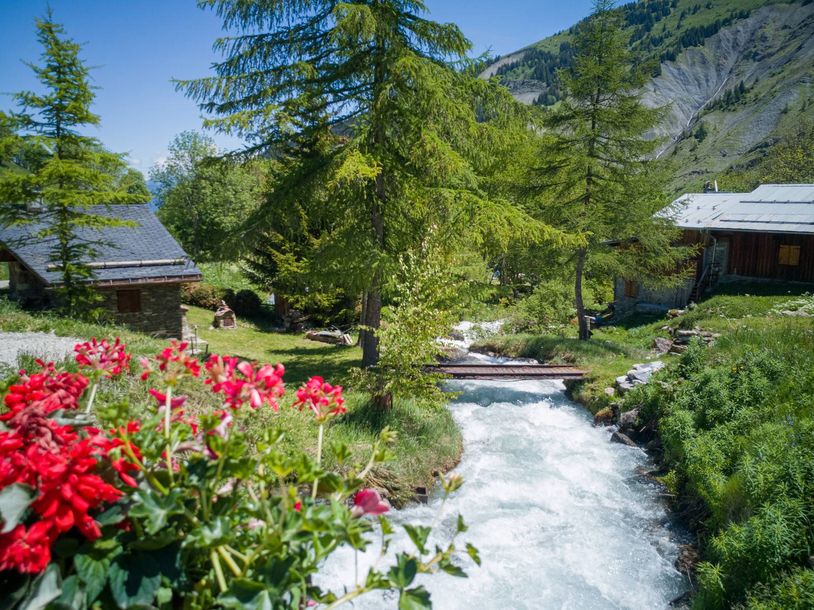
Two remote but magnificent hamlets succeed one another, inhabited for only part of the year. The route is a little steep-sided but nonetheless provides you with fine views of Mont-Blanc, the Vallée des Encombres and the summit of Le Cheval Noir (2,832 metres) when you reach Plan Lombardie – an ideal spot to linger awhile and enjoy a bite to eat.
Description
Short but varied route. This route starting from the hamlet of La Flachère will lead you to the Plan Lombardie refuge. Start on a forest track up to the hamlet of Deux Nants then continue on a small mountain road up to the Saulce. The last ascent to the refuge is a little steeper, but relatively short on a mountain pasture track. The Plan Lombardie hut is equipped with solar panels. You will be able to recharge your e-bike batteries in complete safety.
Follow the green waymarks: Plan Lombardie.
E-bike rental shop:
Skiset Léo Lacroix
Secteur : La Croisette , Résidence Lac du Lou
73440 Les Ménuires
+33 (0)4 79 00 28 15
- Departure : La Flachère - Saint-Jean-de-Belleville
- Arrival : La Flachère - Saint-Jean-de-Belleville
- Towns crossed : SAINT-JEAN-DE-BELLEVILLE
Forecast
Altimetric profile
Recommandations
If in doubt, you can take an introductory lesson in how to ride an electric bike with an instructor.
If you see a herd ahead, slow down and go round it. If there is a patou, a guard dog, climb down from your bike and walk, pushing it alongside you. Avoid making any sudden or aggressive gestures towards the dog and move away from the herd slowly and calmly. The dog will only be checking that you do not pose a threat to its herd. Respect the parkland and close gates behind you after you've gone through them.
The mountain is living, please respect it by staying on the paths and tracks.
Public transportation
Rail service to Moûtiers. Information: www.oui.sncf.com
Then a shuttle bus from Moûtiers to Saint-Jean-de-Belleville
Remember to reserve your shuttles at least 48 hours in advance!
Access and parking
Parking in La Flachère
Parking :
Route planner
Accessibility
- Emergency number :
- 114
6 points of interest
 Architecture
Village of La Flachère
In addition to its panoramic views over the Belleville Valley and Mont Blanc, this “promontory” village contains a chapel of Romanesque origin whose bell tower walls bear the coats-of-arms of the archbishops of Tarentaise. The chapel is dedicated to Our Lady of Lorraine, Saint Anne and Saint Brigitte, and a Cross of Lorraine is engraved above the bell tower’s geminated windows.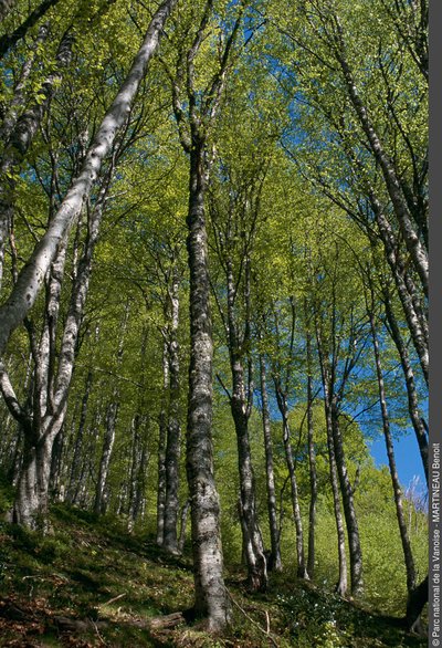
Dans la hétraie - Benoît Martineau  Flora
FloraLongefrasse Forest
This dense forest serves the Valley’s inhabitants in several ways: it protects their houses from avalanches and prevents landslides, and its wood provides them with fuel for heating in winter. Its name means that it is extensive and mostly peopled with beeches, which are usually referred to as “fayards” in Savoie. “Frasse” is a word derived from “fay” which means “beech”.
Hameau des Deux Nants - aptv_redac  Pastoralism
Village of Deux Nants
This village is a “montagnette”: an isolated group of houses once inhabited for only a part of the year (in spring and autumn) by herdsmen making their way between the high mountain pastures in the summer and the village of St-Jean de Belleville in the winter. The hamlet’s name derives from a local word that originally referred to the mountain streams that tumble down the slopes. “Nant” refers to a stream that can cause major damage during spring floods or following a violent summer storm. The hamlet’s chapel is dedicated to Saint St-Claude. It dates back earlier than 1633, the year in which the Bishop of Tarentaise paid it a pastoral visit.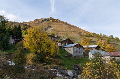
Hameau de la Sauce - aptv_redac ArchitectureVillage of La Sauce
This montagnette, which is crossed by a little mountain stream, is the best preserved village on the itinerary. Its highly typical rural architecture is a fine example of the art of building on a slope! In days gone by, the hamlet’s name was spelled “Saussaz “ but pronounced “Sauce” as, in Savoie, the “az” suffix is not pronounced but indicates that a name is accentuated. It may originally have meant a source of fresh water or a place where fresh water was to be found. Such localities are often situated high up the mountainside. The hamlet’s chapel is dedicated to Saint Barthelemy and was built before 1633. According to the archives, it was built by the inhabitants, who provided it with capital of 100 Savoie florins in 1662. It was renovated in the 2000s.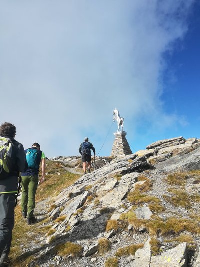
Sommet du Cheval Noir - aptv_redac  Summit
The Cheval Noir peak
This peak wasn't originally named “Cheval”. It came from the patois word “Lanche”, the equivalent of the word “Combe” (Coomb).
Its slopes were dark, almost black in colour
The patois name was eventually Frenchified to become the “Cheval Noir”.
The Cheval Noir’s peak connects 2 municipalities (Saint-Jean-de-Belleville and Saint François Longchamp)
The statue of the horse was recast in 2012 by Jean-Yves Sylvestre; he used stainless steel, a material that does not deteriorate with time.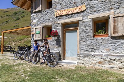
Refuge de Plan Lombardie - APTV PastoralismRefuge Plan Lombardie
Enjoying an ideal location, this mountain hut provides outstanding panoramic views over the La Platière stream at the foot of the majestic Cheval Noir. Rising to 2,832 metres, the Cheval Noir’s summit provides a magnificent view of the Madeleine Pass and the Grand Pic de la Lauzière.
In the summer, the site becomes an extensive area of pastureland shared between several farmers. In the Middle Ages, the word “ Lombard” was used to refer to mountain pastures used by herdsmen from Lombardy who kept their livestock on them. In those days, the Savoyards tended to call anywhere beyond the Alps “Lombardy”.