
Family walk around the Plan de l'Eau des Bruyères
""Imagine the valley 10,000 years ago when the entire valley was covered in ice. Then as the climate warmed up, the glaciers retreated giving way to wetland and peatland. Plants established there, with a procession of birds, amphibians and insects. It is this time difference that I like in this circuit of the Plan de l´Eau tour where you can see part of the largest ski area in the world, as well as plants that had established their presence at the time of the dinosaurs (those from the horsetail family).” Céline Rutten, Vanoise National Park ranger
"Description
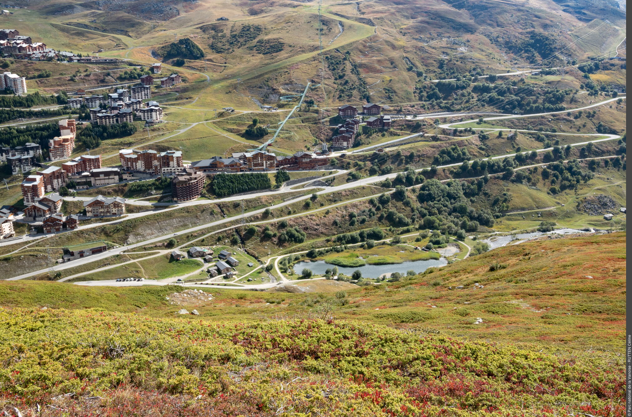
Departing from Bruyères car park, set off on the comfort trail keeping the water body to your left. At the end of the water body, leave the comfort trail to take a path leading towards the bottom of the valley and quickly reach the main track. Go back up this track again still towards the bottom of the valley. Walk along the torrent to reach a bridge at the end of the plateau (1,770 m in altitude). Then return along a wide track overlooking the water body, in the direction of the entrance to the plateau. Reach a section of the track already taken. Ÿou will encounter the comfort trail again. The hike ends upon returning to Bruyères car park with the water body on your left.
- Departure : Plan de l'Eau des Bruyères car park - Les Ménuires
- Arrival : Plan de l'Eau des Bruyères car park - Les Ménuires
- Towns crossed : LES BELLEVILLE
Forecast
Altimetric profile
Recommandations
Particularly fragile environment, do not depart from the paths.
Public transportation
Rail connection to Moûtiers, information: www.voyages-sncf.com. Then transport by coach to Saint-Martin-de-Belleville, information: www.transavoie.com . Free shuttle buses between Val Thorens and Saint-Martin-de-Belleville, information: Transdev Savoie. Departure for the hike approximately 3 km from the village centre.
"Access and parking
From Moutiers take the D117 in the direction of the “Vallée des Belleville”. Pass Saint-Jean-de-Belleville, then Saint-Martin-de-Belleville. At the roundabout of Ménuires continue in the direction of Val Thorens. The Plan de l´Eau des Bruyères car park is located approximately 150 m after Lugeland and at the departure of the Bruyères track on the right.
Parking :
Route planner
Accessibility
Comfort trail accessible to those with reduced mobility with the possibility to complete just the first loop of the tour around Lac des Bruyères. Adapted toilet facilities.
- Emergency number :
- 114
5 points of interest
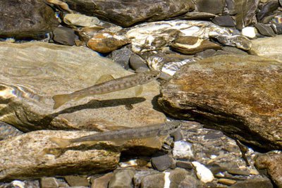
Truite Fario - Mireille COULON  Fauna
FaunaBrown trout in an adapted habitat
All year long, I feed on aquatic insects, molluscs, crustaceans and small fish that I hunt on sight. From November to February, I reproduce on the gravelly bottoms of the Doron and the streams found upstream: the torrents of Lou and Péclet. I lay my eggs there, and the male fertilises them with its milt. The young trout appear in the spring, and rejoin the river downstream which is more favourable to their development. Regular rearing operations carried out by the approved Association of fish and protection of the aquatic environment “the Amicale bellevilloise” helps to support my population.
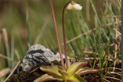
Des fleurs les pieds dans l'eau - PNV  Flora
FloraFlowers at the water’s edge!
"Did you know that there are ""carnivorous"" plants in Vanoise? As their environment is very poor in assimilable mineral matter, the leaves of the butterwort (or Pinguicula: from the Latin pinguis = sticky) are covered with a greasy-looking coating. Insects get trapped on the plant which then ""digests"" their proteins.</ P>"
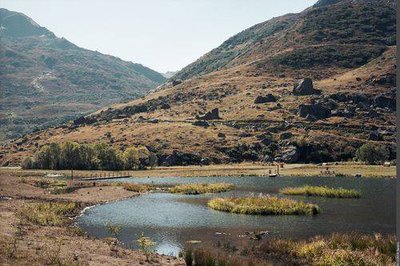
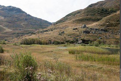
Plan d'eau de loisirs des Bruyères (PNV PO) - VON CONTA Beatrix  Viewpoint
A spectrum of natural environments
The return path rises slightly above the marsh, providing a view of a complete spectrum of natural environments: meadows, more or less humid woodlands, peat bogs, marshes and ponds. The first factor behind the diversity of these environments is the water contained in the soil. Flowing through the site, the Doron des Belleville also contributes to the presence of diverse natural environments.
Plan de l'eau - PNV  Know-how
Protected area
Natural habitats such as the wetlands of the Plan de l´Eau have always been used as a living environment, with 15 species protected at national level and 5 natural habitats recognised by the European Union present there. Since 2003 this natural area has benefited from departmental protection under a decree protecting the biotope.
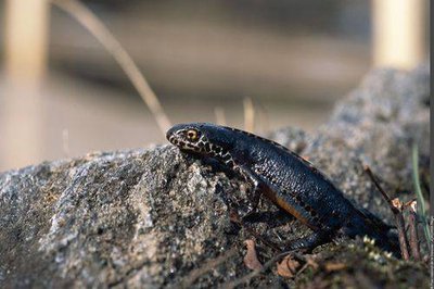
Mâle de triton alpestre en migration (PNV PO) - Régis JORDANA FaunaThe alpine newt
Like all amphibians, the newt ( Triturus alpestris ) is a double agent! The larvae are aquatic, breathing oxygen dissolved in the water using gills; the young and the adults are terrestrial, breathing the oxygen in the air using lungs. This species is very easily observed when it occupies the aquatic environment from April to June. The male has a plain bright orange throat and belly. This protected species can live up to 2,200 m in altitude.