
Vallon de la Leisse
"
The route starts at the alpine pasture chalets of Entre-Deux-Eaux, a pleasant and humid site. Then gradually the landscape becomes wilder: towards the Pont de Croé-Vie, I imagine the mule caravans, the smugglers, the herds passing in Tarentaise. The valley becomes austere but all you need do is open your eyes to discover the charm and magic of the place: starting with the ""Oeil de la Grande Casse” (Eye of the Grande Casse) which, incidentally, it is necessary to open to distinguish this high recumbent fold on the left under the Grande Casse. Still on the same side, the bush-covered screes spread out, changed from one year to the next. These curiosities watch over me, until I arrive at the refuge, a haven of peace amidst the wild nature. Nathalie Tissot, Vanoise National Park Ranger
"
Description
Get off the shuttle at the Pont de la Renaudière. Take the track below which leads to the Refuge d´Entre-Deux-Eaux. Before you get there, take the trail on the left which leads to the Pont de Croé-Vie. Leave the path on the left which leads to the Col de la Vanoise via this bridge and continue straight to the Refuge de la Leisse. Return by the same path.
- Departure : Pont de la Renaudière, Termignon
- Arrival : Pont de la Renaudière, Termignon
- Towns crossed : VAL-CENIS
Forecast
Altimetric profile
Recommandations
Make sure you take the appropriate footwear and equipment: final altitude of 2,500 m. The place is always windy and cold.
Information desks
Maison de la Vanoise, Place de la Vanoise, Termignon, 73500 Val-Cenis
Vanoise Information Desk - Termignon
Place Vanoise, 73500 Termignon
Public transportation
"
"
Access and parking
From the village of Termignon, head towards Lanslebourg. 500 m in at the hairpin bend, turn left on to Bellecombe road. Follow it for about ten kilometres to Bellecombe car park (parking compulsory + shuttle use)
Parking :
Route planner
9 points of interest
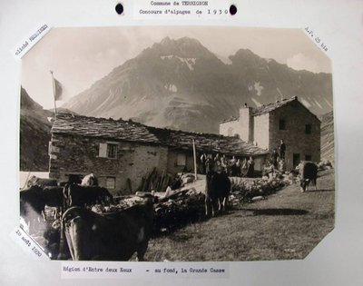
Vue sur le refuge d'Entre-deux-Eaux (1930) - RTM-ONF Chambéry  Viewpoint
View over the Refuge d’Entre-deux-Eaux
View over the Refuge d’Entre-deux-Eaux
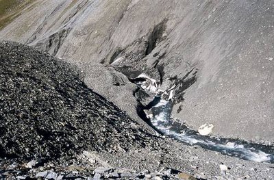
Le Torrent de la Leisse, névés et pierriers de la Grande Casse. Vallon de la Leisse, Termignon. - PNV - TISSOT Nathalie  Water
WaterThe Torrent de la Leisse
Fed by the melting glaciers and névés, the Torrent de la Leisse runs down the valley of Leisse to Entre-Deux-Eaux. There, it converges with the Torrent de la Rocheure to give rise to the Doron de Termignon which passes much lower in the valley at Termignon.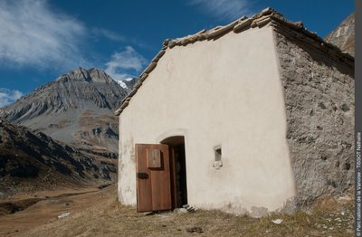
Chapelle Saint-Pierre  History
The Chapel of Saint-Pierre
This chapel dedicated to Saint-Pierre is mentioned as early as 1729. It is the last of the four chapels in the area to be restored. A painting representing Saint-Pierre is now under the custodianship of Marie-Thérèse Burdin, manager of the Refuge d’Entre-Deux-Eaux. A mass was celebrated every summer until the year 2000. The priest received cheese and butter in exchange.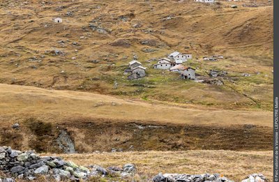
Les alpages d'Entre-Deux-Eaux - Maëlle LEPOUTRE  Architecture
Entre-Deux-Eaux
Of the 97 constructions in the alpine meadows of Entre-Deux-Eaux, this chalet has an atypical pillar with a round section built with lime, which served as a support for the ridge beam. The “Sarde map” (land registry of the kingdom of Piedmont-Sardinia) contained a record of this building as far back as 1728. Accounts tell us that the owning family was so rich “that it placed golden bells on its hens”. The mention of a salt store in the letters of the Stewardship of Savoy, suggest that this remarkable building could be this construction, although no evidence consolidates this version.
 Know-how
Bleu de Termignon
Bleu de Termignon cheese is a rare speciality of Termignon. In the shops you can find the white version, with no trace of marbling, but the best to be found is the blue that you can try from the local alpine farmers…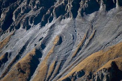
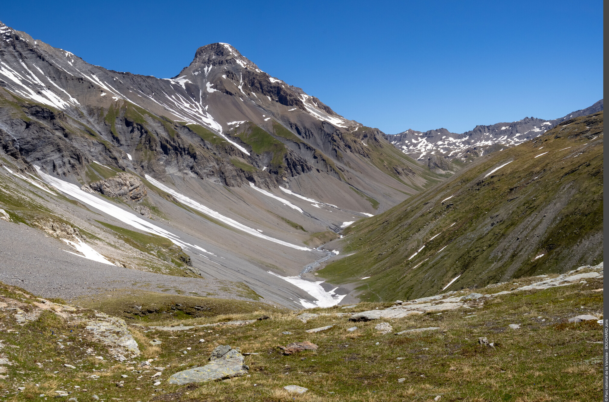
L'"oeil" de la Grande Casse : pli couché, puis roulé. Vue vers N. - PNV - TISSOT Nathalie  Geology
The pli couché
The recumbent fold (pli couché) of the Grande Casse or the “eye of the Grande Casse” on the right bank of the Torrent de la Leisse, masterfully overlooks the wandering hikers (to the left after the Pont de Croé-Vie).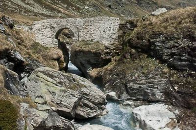
Pont de Croë-Vie enjambant le Torrent de la Leisse. Au fd., la Grande Casse. Termignon. - PNV - TISSOT Nathalie  Small heritage
The Pont de Croë-Vie
The Pont de Croé-Vie, literally meaning “wrong path” in Patois, dates a priori to the seventeenth century. It is a semicircular single-arch bridge with whitewashed stones and a paved roadway. This construction is unique because of the decking height (in relation to floods) and the existence of parapets. The presence of this masonry bridge testifies to the strategic importance of the salt road, because a simple wooden bridge would have sufficed! The bridge was restored by the Vanoise National Park in 2008. It was an historical commercial and military crossing-point between the valleys of Tarentaise and Maurienne. The “salt and cheese road” took this narrow, bad route, leading on one side to the Col de la Vanoise and the Salines royales de Moûtiers, and from the other side to the Termignon cheeses and Italian spices.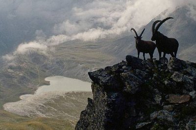
Bouquetins des Alpes mâles. Vue vers le Lac Blanc en contrebas. - PNV - PERRIER Jacques  Fauna
FaunaThe ibex, chamois and marmot
On the right bank of the Torrent de la Leisse, on the sunny side, the ibex (bovidae mammal, Capra ibex) roam, while on the left bank in the shade, you can see the more discreet and wild chamois (Mammifera bovidae, Rupicapra rupicapra). As for the marmots, they take refuge in their burrows at the slightest signal whether from an eagle, fox or hiker (Sciuridae Mammal, Marmota marmota).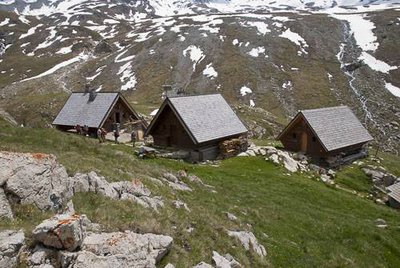
Un midi d'été au refuge PNV de la Leisse, commune de Termignon. - PNV - JOURDAN Jérémie  Refuge
The Refuge de la Leisse
The three wooden chalets that make up the Refuge de la Leisse were built starting in 1970, on a glacial rock bar at 2,500 m in altitude. They are located under the Grande Motte glacier, which gives the landscape a wild and mineral character.