
Tour of the Aiguille de la Vanoise and Col de la Vanoise from Pralognan-la-Vanoise
Description
- Departure : Maison de la Vanoise, Pralognan-la-Vanoise
- Arrival : Maison de la Vanoise, Pralognan-la-Vanoise
- Towns crossed : PRALOGNAN-LA-VANOISE
Forecast
Altimetric profile
Sensitive areas
Bearded vulture
- Impacted practices:
- Aerial, , Land, Vertical
- Sensitivity periods:
- JanFebMarAprMayJunJulAugNovDec
- Contact:
- Parc national de la Vanoise
Jérôme CAVAILHES - 06.89.17.78.02 jerome.cavailhes@vanoise-parcnational.fr
Recommandations
Information desks
290 avenue de Chasseforêt, 73710 Pralognan-la-Vanoise
Maison de la Vanoise, Avenue Chasseforêt, 73710 Pralognan-la-Vanoise
Transport
Access and parking
Parking :
10 points of interest
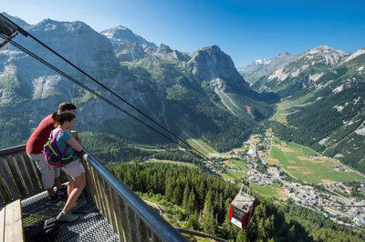
Vue depuis la table d'orientation du téléphérique du Mont Bochor - aptv_redac  Viewpoint
Mont Bochor cable car
To round off your scenic outing, the Mont Bochor cable car takes you up to an altitude of 2,010m in just 3 minutes! At the top, you’ll find an orientation table at an altitude of 2,023m, on the promontory of Mont Bochor, with 360° panoramic views over the Vanoise glaciers and peaks! In summer, this is also a start point for a range of hiking and mountain bike trails.
The history behind the Bochor cable car is a fascinating one! In the olden days, when our ancestors had to cross the mountain ravines, they used ropes on which makeshift gondolas were pulled along, carrying timber or livestock. This system was the precursor to our modern-day cable car! And this is how, in 1951, construction began on the very first service cable car for transporting tools and materials up to Mont Bochor. Timber posts supported the cables on which the cable car would travel. In 1952, the cable car was finally inaugurated after a challenging construction period, and its landmark maiden flight as it were took place that 31 December. In February 1953, it was finally commissioned: at the time it was the fastest cable car in the world!
Facts & figures at a glance:
Altitude of the bottom platform: 1416.50m
Altitude of the top platform: 2002.50m
Elevation gain: 586m
Length: 1086m
Course: 1048m
Journey time: 207 seconds
Max. slope gradient: 92%
Average slope gradient: 66%
10 trips an hour
32 passengers per car
170,000 journeys in winterOpen in the winter and summer.
Find out more in the guide Destination de légende : le téléphérique du Mont-Bochor (in French): https://fr.calameo.com/read/0010480179e1abe5e2695
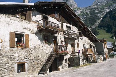
Maison ancienne. - PNV - GARNIER Alexandre  History
The hamlet of Barioz
The hamlet of Barioz comes from the word Barium, meaning “customs barrier”. This is where the salt road begins. All goods were subject to tolls. The Col de la Vanoise was dreaded in bad weather, and before setting off on their journey, travellers would implore the protection of Notre-Dame-des-Sept-Douleurs in the chapel of Barioz. Inside, on one of the paintings you will find Saint-Antoine, a hermit, patron of the mule-drivers, protector of small livestock and domestic animals.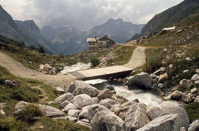
Le pont de la Glière. À l'arr.-pl. : le refuge privé des Barmettes et la gare d’arrivée du télésiège dit "du Génépy". - PNV - GOTTI Christophe  Pastoralism
The Pont de la Glière
"To get to the Glière mountain pasture, you have to cross the stream and an ""invisible barrier"". Effectively, a bridge with a “Canadian passage” prevents the herds from crossing. This consists of cylindrical bars spaced apart and arranged horizontally on the ground. The ungulates (cows, sheep) are unable to cross this barrier. They would risk wedging their hooves in between the bars.The Favre family once worked the Glière mountain pasture and produced ""tomme"" before the appellation ""Beaufort"" appeared. Today, this pasture has been taken over by a young farmer who grazes sheep and produces sheep cheese."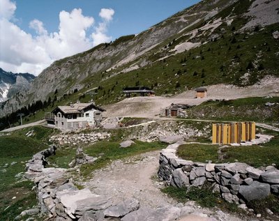
Vue sur le refuge des Barmettes (2007) - PNV - Beatrix Von Conta ViewpointView over the Refuge des Barmettes
The Refuge des Barmettes comes into view in the upper limit of the ski slopes of Pralognan-la-Vanoise, as can be seen in the centre of the image by the detachable chairlift of Génépi, installed during the summer of 2007. The refuge works in winter more like a high-altitude restaurant as opposed to a refuge in the usual sense of the term. In the process of modernisation, the refuge’s façade walls are awaiting new stone and wooden cladding. The grass has grown back on the slopes of the chairlift. The newly green tracks, besides looking prettier, are also easier to groom. To the right, a small light-wood log cabin houses the ski patrollers and an emergency station.
Les Chalets de la Glière et les murets qui bordent la "route du sel et des fromages" (Pralognan la Vanoise, PNV CP). - PNV - GOTTI Christophe  Small heritage
Downstream of the chalets of la Glière is the salt road
Downstream from the chalets of la Glière, you will merge onto an old mule road lined with dry stone walls. It was used for pack-saddled and shod animals to carry heavy loads. The low walls prohibited passing animals from entering the meadows. Some stones are engraved and bear witness to the repeated passages of man from the Neolithic to the present day.This route, known as the “Salt Road” was also of strategic importance for the counts and dukes of Savoy and the kings of Piedmont-Sardinia for salt trading. It was also used to access the alpine pastures, transport the cheeses and to get to Maurienne. Finally, the alpine hunters, in charge of defending the frontiers, found the salt road to be the perfect ground for their training. Pastoralism
The lower chalet of Arcelin
The lower chalet of the Arcelin is used as a shepherd’s hut (Arcelin is a derivative of archellins, arcelle, arch and means habitation, shepherd’s hut). This type of chalet was used between mid-June and the end of September by families who left the village of Pralognan and settled in the mountains. The farmers would make the cheese (tomme) on site.
Le Lac des Assiettes, asséché (Pralognan la Vanoise. PNV CP). Vue sur le Glacier des Grands Couloirs et la Grande Casse. - PNV - GOTTI Christophe  Lake
LakeLac des Assiettes
10,500 years ago, the tongue of the Glacier of the Grands Couloirs / Réchasse which flowed towards the valley of l´Arcelin stopped at the Lac des Assiettes. This formed a moraine-dammed lake at the level of a limestone rock bar. During the Little Ice Age, the Lac des Assiettes was obstructed by an independent underground ice cap system. This could hold water for a large part of the summer months and perhaps year round thanks to the great periods of glacial flood (1550-1650, 1700-1780, 1820 -1860) according to Bravard and Marnezy (1981).Today we are witnessing the death of this lake because of “alluviation”. In fact, alluvial erosions upstream (pebbles, gravels, clays ...) which are transported by the torrents, filled this lake. The latter are swiftly colonised by pioneer plant species (linaria alpina, Silene acaulis).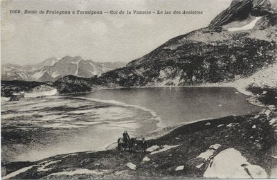
Vue sur le lac des Assiettes (1910) - Collection V.O. Communication ViewpointView over the Lac des Assiettes
Located on the old commercial and tourist route from Pralognan to Termignon by the Col de la Vanoise, the Lac des Assiettes, below the Vanoise pass and needle, completely dried up in 1995. The existing plan of course keeps track, but with the loss of a picturesque reflection of the sky, it is also a biotope, an essential element of ecological diversity.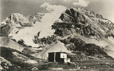
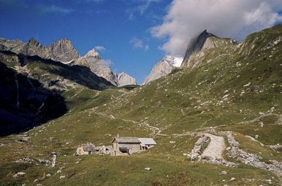
Vue sur le Col de la vanoise (1935) - Editions Dauphin ViewpointView over the Col de la Vanoise, the Refuge Felix Faure and the Grande Casse
The commercial crossing of the Col de la Vanoise has evolved into a mountaineering base at the Grande Casse, the highest peak in Savoy, with a series of refuges providing accommodation since 1878, including the famous Félix Faure, built in 1903 by the CAF, completed in 1974 by two prefabricated buildings classified as twentieth century heritage and now replaced. But the evolution mainly concerns the melting glacier of the Grands Couloirs, particularly the 1935 tongues that changed the historic route of ascent of 1860, but also the tongue of 1820-30 as the lateral moraines would indicate.
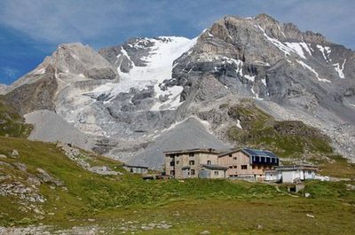
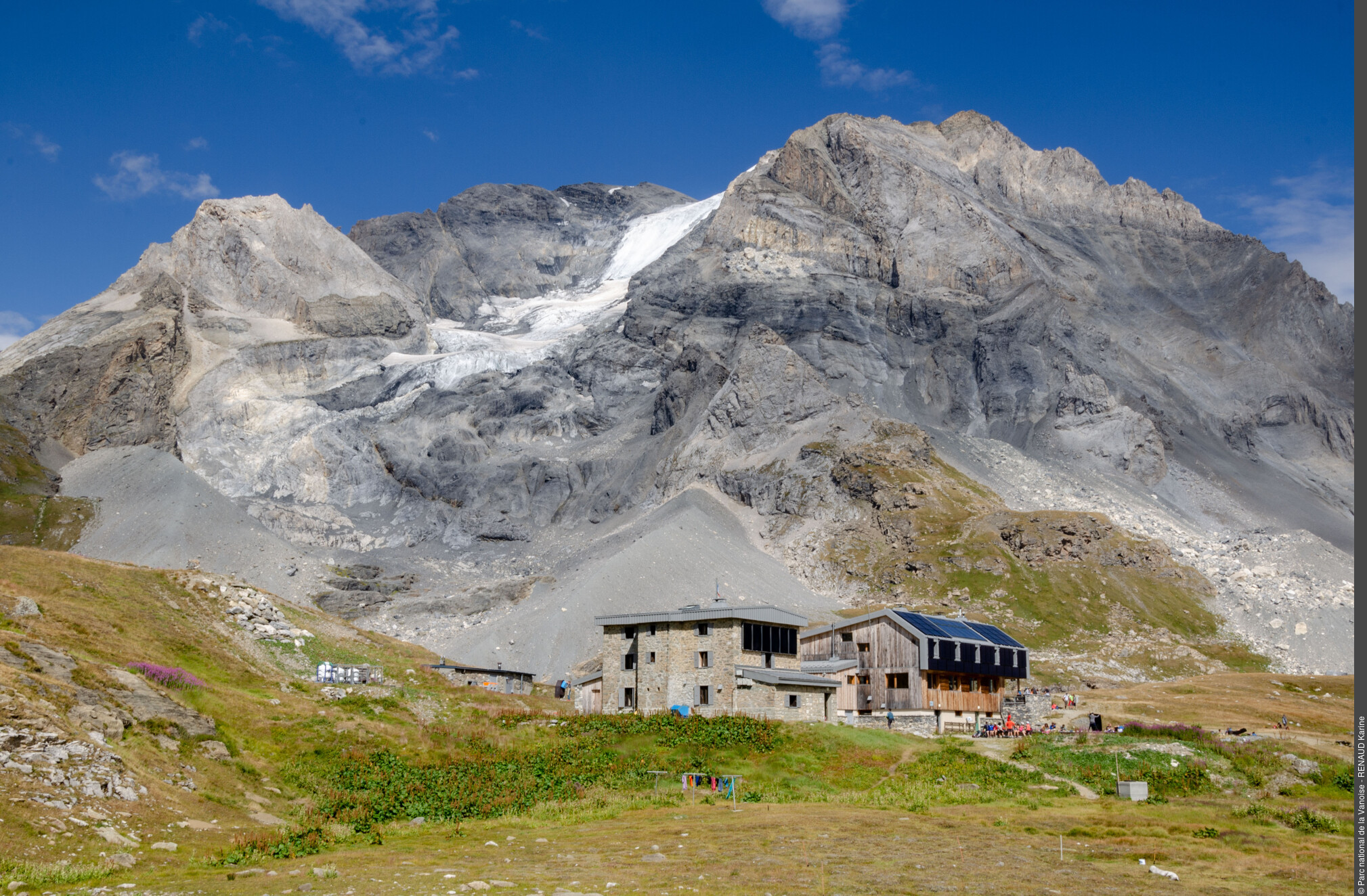
Refuge CAF du Col de la Vanoise. A g., le bâtiment historique de 1902. - PNV - GOTTI Christophe  Refuge
The Refuges of Col de la Vanoise.
"Five refuges have been built at the Col de la Vanoise. The first was built between 1876 and 1879. Its ruins are still visible from the Lac des Assiettes. The second stone refuge dates back to 1902. It was named after the President of the Republic Felix Faure, who was also renowned for his death in charming company. Then, in the 1970s, two prefabricated buildings were added. In 2000, the refuge changed name to become ""Refuge du Col de la Vanoise"". Finally, a 5th refuge was opened in 2014 to replace the 2 prefabricated buildings. It belongs to the Club Alpin Français."