
Tour of Vuzelle
PRALOGNAN-LA-VANOISE
Tour of Vuzelle
Difficult
2j
16,8km
+1799m
-1802m
Loop
Embed this item to access it offline
Description
"From Pralognan-la-Vanoise, take the Bochor ski lift and follow the trail up to the Col de Leschaux, then follow the trail in the direction of ""Refuge du Grand Bec”. After the night at the shelter, take the trail that gœs down to the valley to the north, in the direction of ""Plan Fournier”. After 450 m of downhill ascents, at the first fork in the path, take the left path; follow the direction for “Mont Chevrier / Pralognan-la-Vanoise”. After 300 m of downhill ascents, at the intersection of the Touros wood, take the path that gœs south. After 250 m of a ""downhill flat"" path, take the path that gœs flat at this intersection. After about 300 m, cross the Vuzelle stream. 150 m after this stream, take the intersection in the clearing, the path on the left that gœs up (390 m) to the crest of Mount Chevrier. At the 1st intersection, take the lower trail. At the 2nd intersection, take the trail on the left and follow the direction of ""Pralognan-la-Vanoise”. At the next 2 intersections, follow the branch on the left. At the next intersection, take the trail on the right that gœs down. After the thalweg of the Combe des Pariettes, take the trail that gœs down the combe. After walking for about 600 m, take the paved road to Pralognan village centre."
- Departure : Departure station of the Bochor ski lift
- Arrival : Village church
- Towns crossed : PRALOGNAN-LA-VANOISE and PLANAY
Forecast
Altimetric profile
Recommandations
Please note that the crossing of the trail between the Aiguille du Bochor and the Col de Leschaux is overhead and can be covered in late névés. This tour is best made late in the season, not before the end of July. Book your overnight stay at the refuge and your picnic for the 2nd day.
Information desks
Maison de la Vanoise, Avenue Chasseforêt, 73710 Pralognan-la-Vanoise
290 avenue de Chasseforêt, 73710 Pralognan-la-Vanoise
Public transportation
"
Rail connection to Moûtiers. Information: www.voyages-sncf.com
Then transport by coach to Pralognan-village. Information:www.transavoie.com
"Access and parking
RD 915 to Pralognan la Vanoise
Parking :
Village centre, Pralognan-la-Vanoise
Route planner
More information
10 points of interest
 Pastoralism
Leschaux
"Ÿou are at the Col de Leschaux, overlooking the eponymous ravine on its south-facing slope. The term ""leschaux"" most likely comes from the pre-Roman ""calmis"" which translates as ""pastureland"", ""meadows"" or even ""alpine pasture""."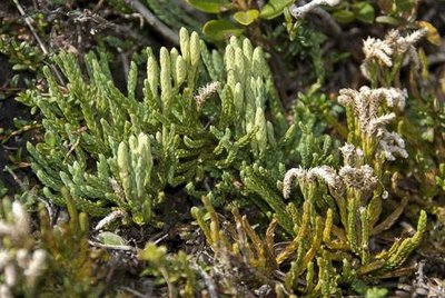
Lycopode des Alpes avec ses épis sporangifères. - PNV - STORCK Frantz  Flora
FloraAlpine clubmoss
The alpine clubmoss (Diaphastrum alpinum) is bound to the short, dry moors, on an area of bare ericaceous shrubland (heather). It is an artico-alpine species, which, as the adjective describes, is native to northern Europe. It found refuge at altitude in the Alps when global warming took place after the last ice age. It is a protected species in France. Other than autumn when its light green reproductive stems are visible, it is barely detectable to the layman’s eyes.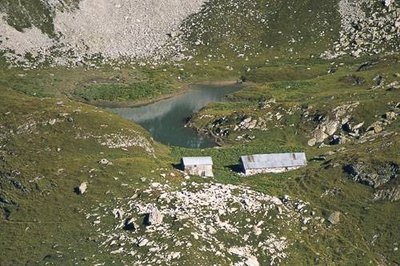
Chalets de la Vuzelle au bord du lac de la Vuzelle, commune de Planay. - PNV - GOTTI Christophe PastoralismAlpage de la Vuzelle, yesterday and today
The alpine mountain pasture of Vuzelle is one of 3 communal mountain pastures of Planay. Historically it welcomed a part of the hamlets’ dairy cows and the cheese was made on site in the summer. Currently, only one herd of heifers occupies the place in summer. A peculiarity of the mountain people is that some towns have mountain pastures over towns at higher altitude, thus the town of Planay has the mountain pastures of Ritort and Nants over that of Pralognan-la-Vanoise.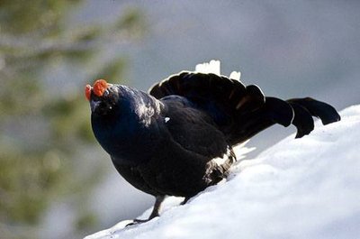
Coq de tétras-lyre pendant les parades du printemps. - PNV - BENOIT Philippe  Fauna
FaunaA helmet and vest are compulsory
Ÿou cross a forest boundary! It´s nothing to be alarmed about, it’s an area where the forest gradually colonises the rhododendron moors. This area at the upper limit of the forest is a vital habitat for the black grouse (Tetrao tetrix). Effectively, this concentrated area allows it, by turns, to nest (semi-woody cover), to raise the young (insects, berries and grasses), to feed in autumn (bilberries) or even in winter (tree buds) and to host its courtship displays. The gîte and the cover.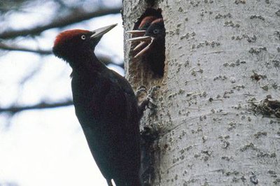
Pic noir. - PNV - MOLLARD Maurice FaunaLodgers, one after another
In the spruce trees before you, two birds use the same nest successively. Indeed, in the big spruces, the black woodpecker (Dryocopus martius) hollows out its nest, a box, directly in the trunk. After one breeding season, the woodpecker abandons its house. The Tengmalm´s owl follows it the year after, in order to lay its eggs and raise its offspring. So, if there are no old spruces, there are no black woodpeckers; no black woodpeckers and there are no Tengmalm´s owl!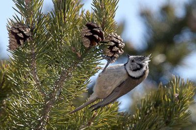
Mésange huppée : individu en train de se nourrir sur un cône de pin sylvestre. - PNV - PLOYER Jean-Yves FaunaProcession of titmice
Different environments cœxist along this route: spruce, alder, mixed forest with deciduous trees. Thus, the guild of tits presents a complete spectrum of species such as the great tit (the biggest), the coal tit, the European crested tit or the slender long-tailed tit. It often happens that during the winter, all these species gather together in large flocks (several dozen birds) to protect themselves better from their winged predators (Eurasian pygmy owl or Eurasian Sparrowhawk).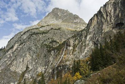
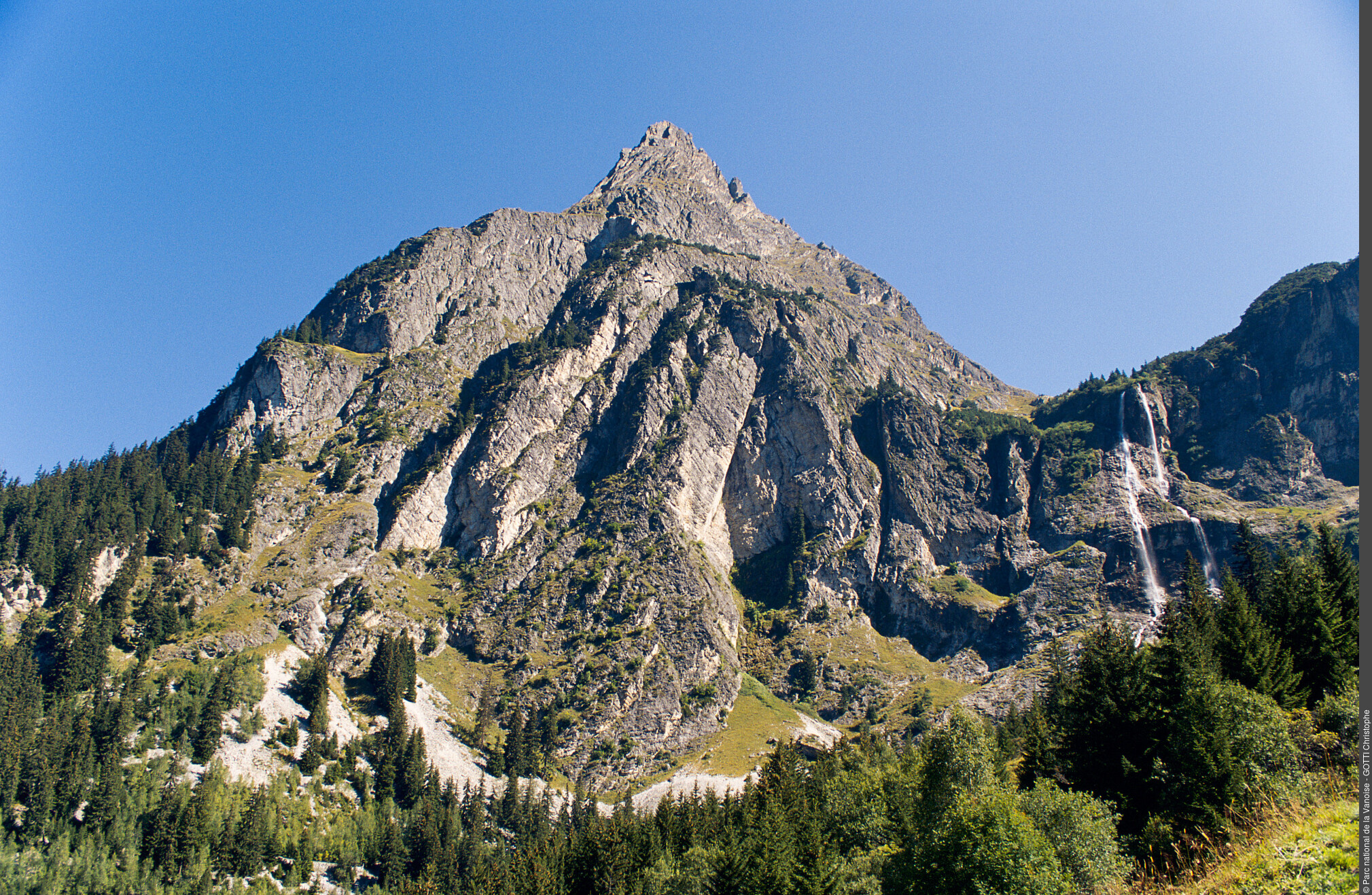
La Cascade de la Vuzelle et la Pointe de la Vuzelle. - PNV - GARNIER Alexandre  Water
WaterRuisseau de la Vuzelle Waterfall
The Vuzelle waterfalls collect the waters of the watershed which gœs from Grand Bec up to the Pointe de Leschaux, via the Pointe du Creux Noir. Advice: in the mountains, do not rely on the freshness and purity of the water for drinking. In effect, the corpse of a wild or domestic ungulate in the watershed can lead to a bacteria proliferation which is invisible to the eye! This being said, the sight of a waterfall is always a moment of inner calmness. Viewpoint
Viewpoint from Mont Chevrier
As you descend the valley’s axis, you will see Mont Jovet (2,558 m in altitude), on its right before you, you recognised it, the Aiguille de la Vuzelle (2,573 m in altitude). To the back of the village of Pralognan-la-Vanoise, you can admire the Vanoise glaciers, the largest continental European ice cap covering nearly 1,960 ha, culminating at the Chasseforêt dome at 3586 m. Returning to the west, the Dents de la Portetta and the Crête du Mont Charvet bring you north to the Dent du Villard (hidden).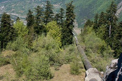
Conduite forcée du Belvédère des Pontets. - PNV - GOTTI Christophe WaterIt gurgles under our feet!
Here you will find yourself directly above one of the many tunnels piercing the Vanoise mountain range. The “white coal” is the only industrial electrical production in Savoy. The hydrœlectric plant located at the Villard du Planay turbine, in addition to the water of the Champagny-le-Haut valley, part of the waters of the Vanoise and the Doron de Chavière, via a tunnel in the mountain and a pressure pipe-line. And please, no laser sight!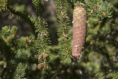
Cônes d'épicéa avec perles de résine. - PNV - BALAIS Christian  History
The Darbelays
"Ÿou are in the locality of “Les Darbelays”. In local Patois, a darbel is a young spruce plant. Thus, the Darbelays translates to a spruce nursery; the locality of ""Les Darbelots"" in Planay, probably translates to a spruce forest, known as “pessière” in French."