
Loop of the Refuge de la Valette
My 30 years of care-taking allowed me to follow all the changes made to the refuge, from the means of communication, to the supplies, bookings and family life. So in 30 years I have gone from 2 daily radio sessions with the village to an almost continuous connection with the entire world via satellite internet. The 2008 expansion completely changed the caretaking conditions, meaning no more trips back and forth in the rain, snow and wind between the kitchen located in one building and the dining room in another. The soup is now served hot! Friendliness and closeness with the guests are more important. In addition, the birth of my children in 2000 and 2001 made it possible to expand the refuge team and watching them evolve in this environment is a privilege!
Sylvie Richen, caretaker of the Refuge de la Valletta.
Description
"Bypass the Olympic ice rink and follow the GR©55 towards the south-west (Chavière valley). In the spruce forest, take the second trail on your left in the direction of “Pas de l´Âne / Refuge de la Valette”. Above the cliffs and the forest, at the fork in the road ""Pas de l´Âne 2,062 m"", follow on the right in the direction of ""Refuge de la Valette 2 h"". At the fork in the trail located 10 minutes from the Refuge de la Valletta, turn off to the left to access the refuge. Then go down heading southwards and join the Chalet des Nants. Follow “Les Prioux 1 h”. Cross the Nant stream and enter the alder forest (plant formation with green alders). Follow on your right the paved road to join the GR©55 at the hamlet of Prioux. Follow the GR©55 on the left bank of the Doron de Chavière, then on the right bank, up to your starting point via the forest."
- Departure : Olympic ice rink, Pralognan-la-Vanoise
- Arrival : Olympic ice rink, Pralognan-la-Vanoise
- Towns crossed : PRALOGNAN-LA-VANOISE
Forecast
Altimetric profile
Sensitive areas
Bearded vulture
- Impacted practices:
- Aerial, , Land, Vertical
- Sensitivity periods:
- JanFebMarAprMayJunJulAugNovDec
- Contact:
- Parc national de la Vanoise
Jérôme CAVAILHES - 06.89.17.78.02 jerome.cavailhes@vanoise-parcnational.fr
Recommandations
"Take the route in the direction of the climb by the Pas de l´âne. Don’t hike when the rocks are damp. Between the ""Pas de l´Âne"" and the ""Roc du Tambour"", a rocky slab may prove tricky to cross because of ice and snow. Find out more information at the Refuge de la Valette on 04 79 22 96 38."
Information desks
Maison de la Vanoise, Avenue Chasseforêt, 73710 Pralognan-la-Vanoise
290 avenue de Chasseforêt, 73710 Pralognan-la-Vanoise
Public transportation
"
"
Access and parking
RD 915 to the Olympic ice rink
Route planner
Accessibility
NO
- Emergency number :
- 114
More information
10 points of interest
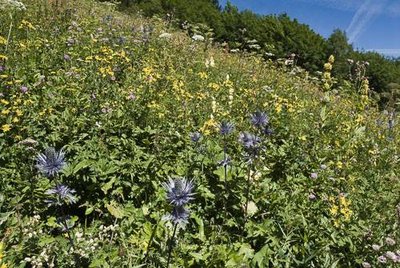
Prairie à chardons bleus. - PNV - GARNIER Alexandre  Flora
FloraThe blue thistle path on the GR®55 (Couloir des Diés)
The Blue thistle (Eryngium alpinum) is a rare, declining and protected species in France. It lives mainly in the hay meadows and some avalanche paths between 1,000 and 2,000 metres in altitude. It dœs not tolerate competition with shrubs and overly premature grazing. When the paths where it grows are no longer used by agriculture, the Vanoise National Park conducts late mowing to maintain the species.
 Water
WaterChavière water abstraction point
Four water abstraction points capture the waters of the Doron de Pralognan and its smaller tributaries - the Chavière, Glière, Isertan and Vuzelle - before they are transported to the power plant. This is the Chavière water point. 8m3/s transit through an underground gallery around 13km long with a diameter of more than 2 metres and join a 1,700-metre penstock with a change in gradient of 765 metres.
Find out more about the Pralognan power plant (in French): https://www.edf.fr/sites/default/files/Hydraulique/pays-de-savoie/documents/EDF_Pralognan.pdf
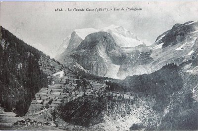
Vue sur la Grande Casse (1910) - Collection V.O. Communication  Viewpoint
View of the Grande Casse
This renewed postcard summarises both the main physical changes to the landscape –glacial melting, forest recolonisation and agropastoral decline. The Grande Casse, the highest summit of the Vanoise massif and hallmark of the National Park, seems to provide a generous cradle to man who offers his thanks by drawing a heart in the centre of the landscape.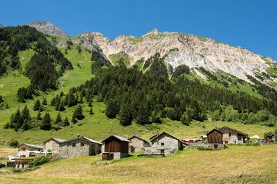
Le hameau des Prioux - Gilles Lansard  History
Les Prioux hamlet
At the edge of Vanoise National Park, Chavière Valley unveils its natural wonders along a refreshingly varied path: the Savoyard discovery tour around Les Prioux.
Life in this hamlet, perched at an altitude of 1,700m, is still very much in step with nature and the winter and summer seasons, and residents have had to adapt accordingly. As they are cut off from the world through the long winter months, they have so much to share with you about life in the past: the mountain pastures, making Beaufort cheese, the growth of tourism and mountain crafts and trades...
This refreshingly varied path unveils the wonders of Chavière Valley to you, with its awe-inspiring peaks and more relaxing hamlets.
The route is accessible to everyone, including families with pushchairs, the elderly and wheelchair users with helpers.
• Round trip takes: 40 minutes
• Elevation gain: 10 metres
• Distance: 1km 100
People with reduced mobility can reach Les Prioux via an adapted shuttle bus.
Open from 15 May to 30 September, except if snow closes the road to Les Prioux.On-site you’ll find a cheese dairy, restaurants and accommodation options, to make a proper holiday out of your trip!
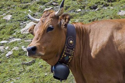
Vache de race Tarentaise. - PNV - BASSARGETTE Denis  Know-how
Les Prioux
"Stop at the hamlet of Les Prioux, to witness (depending on the time) the making of Beaufort at Rolland. This cow’s cheese, cooked, pressed and smear-ripened (salted and rubbed) has been labelled PDO (formerly CDO) since 1968. It is known as the “prince of gruyères”. Only the tarentaise and abondance breed can claim to give their milk. The appellation ""Beaufort d´Alpage"" is attributed only to cheeses made in summer, with the milk of a single herd, as is the case with your hosts."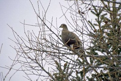
Tétras-lyre, femelle. - PNV - MÉLÉ Stéphane FloraBéveriers alder
"Ÿou cross the green alder (green alder shrubland) mixed with the rhododendron moors. There are two types of green alder: one linked to the colonisation of abandoned pasture lands, the other to avalanche paths. In the second case, in the manner of Jean de la Fontaine’s reed, the alder ""bends but dœs not break"" as the avalanche passes. It is also an outstanding habitat for the black grouse (Tetrao tetrix), providing shelter and cover, particularly for rearing chicks."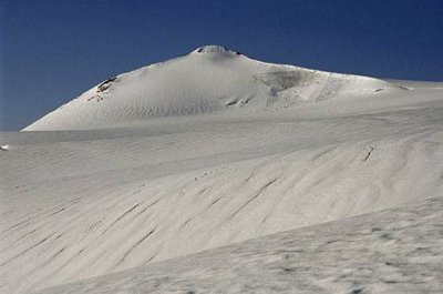
Le Dôme de Chasseforêt, face Nord. - PNV - GOTTI Christophe  Glacier
Ice cap
"Looking up, you can admire the brim of the ice cap of the Vanoise glaciers. Approximately 13 km in length, it is the largest glacial ice cap in continental Europe. It appears in the form of a succession of several domes and culminates at the Dôme de l´Arpont at 3,599 m. This immense expanse of ice was nicknamed ""white desert"" or ""small Arctic"" by Roger Frison-Roche. Numerous torrents flow from this cap. They are referred to as “Nants” and are visible within the cirque of the same name."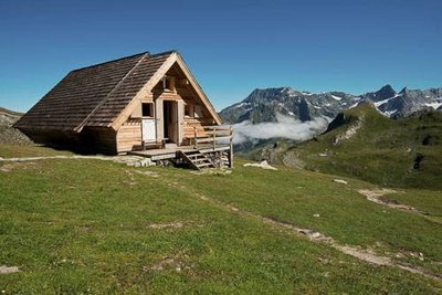
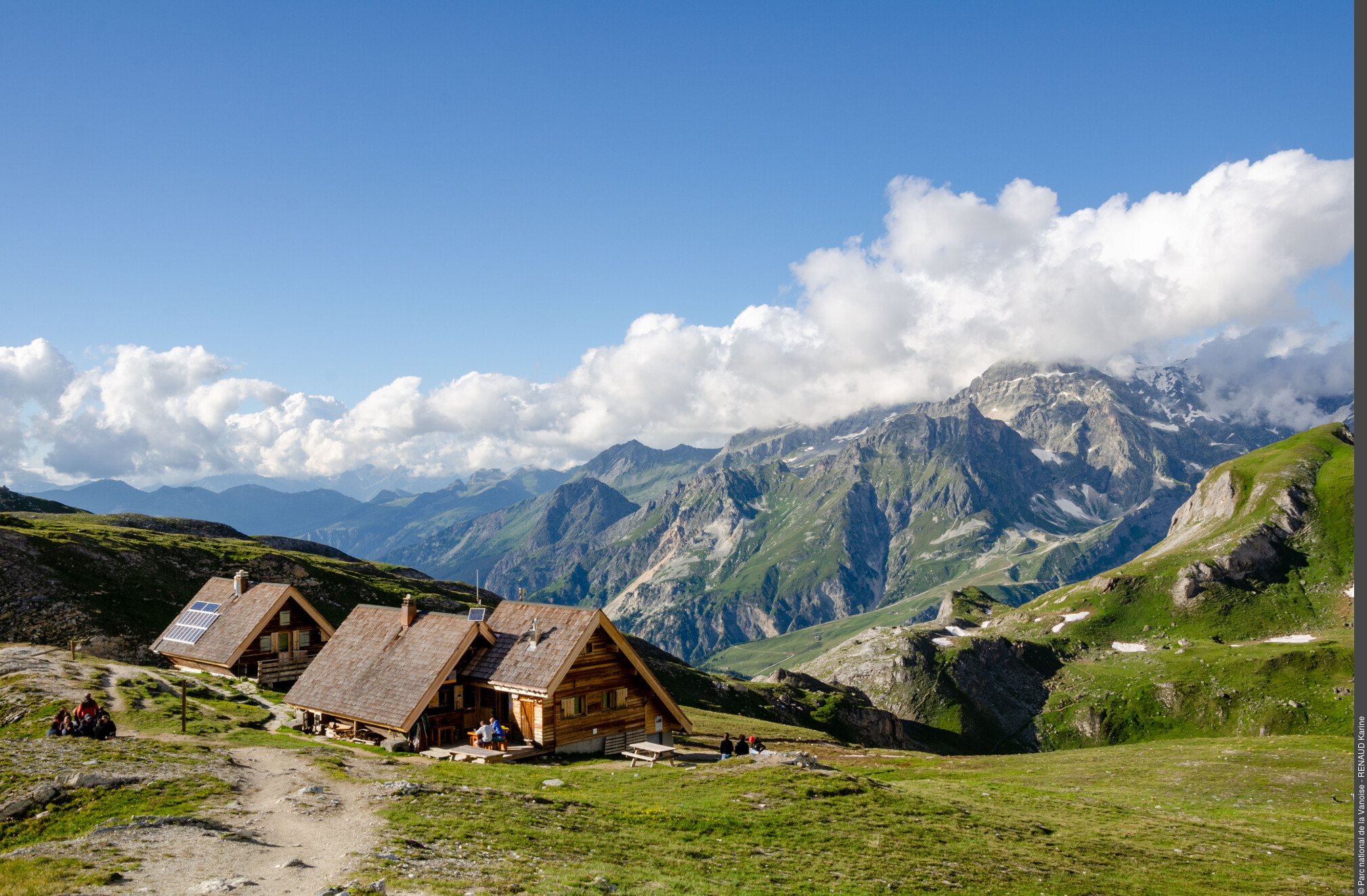
Le bâtiment abritant les dortoirs du refuge PNV de la Valette (à g.) et le Roc du Tambour (à dr.) - PNV - BUCZEK Jessica  Refuge
The Refuge de la Valette
The Refuge de la Valette comprises 3 “Chaloin” chalets, named after the creative company. From 1968, the Park was equipped with 9 sites with this type of construction. With a minimum of preparation (creation on site of beams or a concrete block base), the shelter was built in 3 weeks (stove, dishes and blankets included!). To the south-east of the Refuge de la Valletta, below the Peak of the Vieille Femme, you can see the ruins of the old refuge. It dates from 1899. During its first ever winter, its roof was carried away by a storm. It was opened in the late summer of 1900. This refuge consisted of four rooms: on the ground floor, a room for the keeper and a stable for the mules and, upstairs, two rooms with camp beds, reserved for tourists.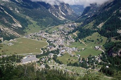
Vue sur le village de Pralognan. - PNV - GOTTI Christophe ViewpointPralognan-la-Vanoise
"Pralognan-la-Vanoise takes its name from ""Pralognan"", formed from the Latin roots pra and longianum: the distant meadow, and ""Vanoise"", perhaps derived from the Celtic vanno which means slope and by extension ""Rock”. The first human traces discovered at Pralognan date back to the Iron Age (5th century BC). It was only in the Middle Ages that a permanent habitat developed. The settlement of Pralognan is linked to the creation of a priory in the 12th century by the monks of Saint-Augustin."
La forêt communale de Pralognan la Vanoise. Commune de Pralognan la Vanoise. - PNV - AUGÉ Vincent FloraThe Isertan forest
Ÿou cross the forest of Isertan. It consists of a mixed spruce forest (spruce forest, mix of deciduous trees: aspen, mountain ash tree, etc.) at the base of the slope, as a result of logging, then pure spruce, followed by cembro pine trees at the foot of a cliff) and vegetation linked to the avalanche path with green alder, young larch, and rhododendron moors. Along the track, you may come across the discreet lesser twayblade (Listera cordata), a magnificent orchid with green star-shaped flowers.