
Vallon de l'Orgère
The valley of Orgère is a natural setting hanging over the Maurienne Valley where a wild and ancient forest shares the space with meadows maintained by several generations of farmers. Here, both wild and domesticated nature live in perfect harmony under the ominous but benevolent vigilance of the Aiguille Doran.
Description
Park in the Orgère car park located after the refuge at the end of the road. Then take the old EDF track, located at the bottom of the car park. Follow the discovery trail marked by landmarks and equipped with visual, audible and tactile interpretation stations. Pass a concrete bridge that straddles the Povaret stream to reach the foot of the Aiguille Doran. Here the section of the trail labelled “Promenade de confort” ends. For people with reduced mobility and pushchair users, return to the car park by the outward route. For hikers wishing to complete the loop, follow a path to a wooden footbridge to cross the Masse stream. Continue along a winding path until you reach a crossing which is also the summit of this hike. At this crossing, turn right following the markers for the discovery trail. After walking through the rhododendrons, enter the heart of the forest, while continuing to descend gradually, exit the forest to reach a second crossing, located near the chalets. Take a right on an off-road track, arrive at a stone bridge crossing the Povaret stream. Continue on, then cross a group of buildings, including a chapel on your left. Follow the markers for the discovery trail and climb through a softwood forest by a winding path. Come out on to a road, climbing back up to reach the car park.
- Departure : Orgère car park, Villarodin-Bourget
- Arrival : Orgère car park, Villarodin-Bourget
- Towns crossed : VILLARODIN-BOURGET
Forecast
Altimetric profile
Recommandations
As the trail largely borders the heart of the park, you are strongly advised to keep any dogs accompanying you on a leash. This also prevents any interactions with animals in the mountain pastures.
Information desks
Maison Cantonale, 9 Place Sommeiller, 73500 Modane
Transport
Rail connection to Modane. Information: www.voyages-sncf.com
Then transport by coach to Villarodin. Information: www.transavoie.com
No public transport between Villarodin Orgère car park.
Suggested hitchhiking organised in the Haute-Maurienne valley. Information: www.rezopouce.fr
Access and parking
From the exit of the A43 motorway, take the direction of Modane. At the Freney roundabout, take the RD 106 towards the Refuge de l´Orgère which is signposted. After a 30 minute drive, pass the Refuge on your right to access the car park.
Parking :
Accessibility
Accessible path of about 1.4 km for people with reduced mobility and motor disabilities, certified
”Promenade confort” (comfort trail), with two disabled parking spaces. The trail is punctuated by
stations consisting of tactile features, models and sound stations. The National Park’s Refuge-Porte de l´Orgère has been certified “Accessible Tourism” for the 4 disability types since 2014.
- Emergency number :
- 114
10 points of interest
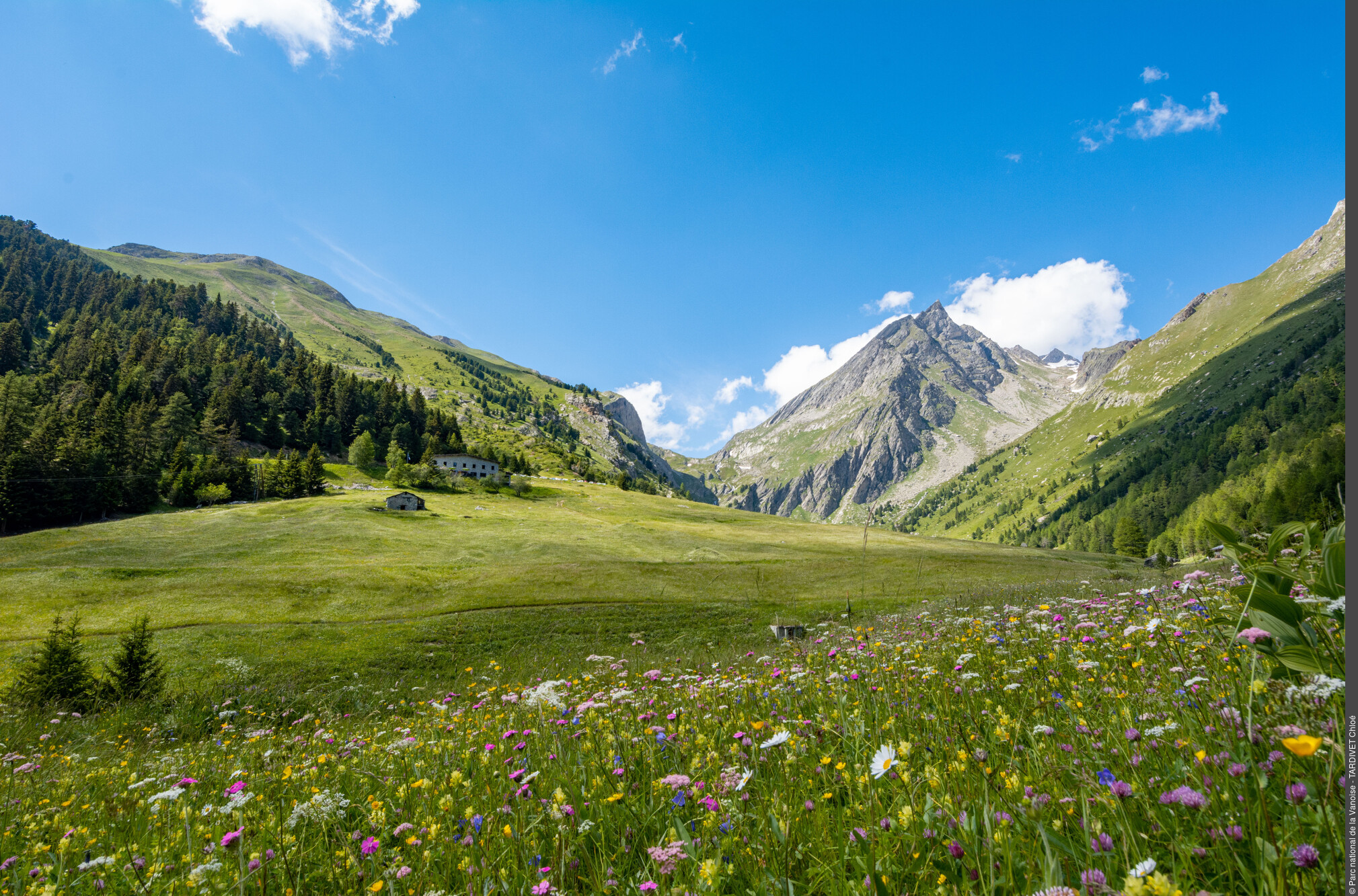
Refuge-porte de l'Orgère. Vue sur l'Aiguille Doran et le Vallon de la Masse. - PNV - PERRIER Jacques  Refuge
Refuge de l’Orgère
Acquired in 1969 by the Vanoise National Park, former residence of EDF workers, the Refuge de l’Orgère is one of the 4 “refuges-portes” (gateway shelters) of Vanoise National Park.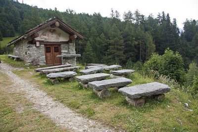
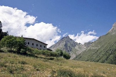
Chapelle du Vallon de l'Orgère. - PNV - DEFFRENNES Benoît  Architecture
Chapel of “Notre-dame-des-Neiges”
During the summer, it was difficult to get down to the village for church services. Chapels were therefore built on the mountain pastures. The lauze roofing and architecture of the building show us how local materials were once used, with the sparing use of wood. In order to avoid mountain hazards such as rock falls and avalanches, the religious buildings such as oratories or crosses figure prominently on the mountain.
Pic noir. - PNV - MOLLARD Maurice  Fauna
FaunaThe black woodpecker and the boreal owl
"Although timid, the largest of the European peckers rarely gœs unnoticed because of its ""kraaak kraaak kraaak"" cries in flight often followed by a powerful ""zhreee"" when it lands. Black and the size of a crow, the male has a red cap covering the whole skull which is limited to the neck in the female. Seeking out old trees to dig its nest, its role is decisive for the boreal owl. This boreal forest owl cannot dig its own home in the wood, so it must use the old homes made by the black woodpecker."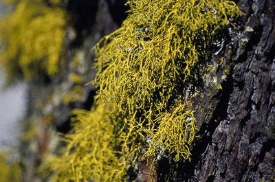
Lichen du loup. - PNV - TISSOT Nathalie  Flora
FloraLichens
A lichen is the fruit of a symbiosis between an algae and a fungus: the fungus protects the algae, giving it water and mineral salts and the algae produces sugars and other products, which it shares with the fungus. An excellent indicator of air quality, capable of withstanding extreme living conditions, there are a great many species in the Orgère forest, including wolf lichen, which grows almost exclusively on the larch tree. With a bright sulphur-yellow colour, it is the only toxic lichen in France. Legend has it that it takes its name from its alleged use as a poison against the wolf.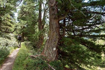
Mélèze remarquable bordant le sentier de découverte du vallon de l'Orgère. - PNV - BUCZEK Jessica FloraThe Orgère forest
Comprised of a mixture of cembro pines and European larches, the Orgère forest has derived its richness from the absence of logging since 1943. As a result, it has ecological characteristics that bring it closer to primary forests with many centuries-old trees and a large proportion of dead wood.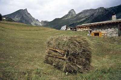
Ballotin de foin résultant de la fauche à la main autour des chalets de l'Orgère. - PNV - BREGEON Sébastien ArchitectureThe chalets
"When most of the flat areas, more suitable for building chalets, were occupied, it was necessary to build on the slope, in areas more exposed to avalanches. Some chalets therefore had to be built with a specific architecture in order to resist avalanches: semi-buried, oriented in the direction of the slope and protected by a protective promontory called a ""tourne""." Fauna
FaunaThe red deer
As a result of hunting and logging, the deer had all but disappeared from the Savoy forests. Reintroduced between 1958 and 1973, it has adapted remarkably well to the mountain environment to form a fine population. In autumn the mating season gives rise to spectacular fighting between males, but it is the raucous and powerful cries of the deer that bring the valley to life. Taking advantage of the peacefulness of the place, the animals bellow practically all day long.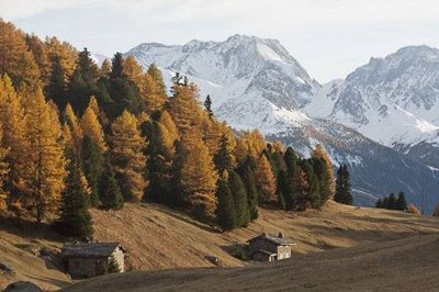
Chalets du vallon de l'Orgère en automne. - PNV - DEFRENNES Benoit FloraThe colours of autumn
If you get the chance, do this hike in the autumn. The mélézin is adorned by beautiful golden hues. The large-fruit fireweed opens up to release a multitude of seeds surmounted by silky-white snow like threads. And higher up the ubac, the bilberry moors take on a beautiful red hue. Under the effect of the first frosts the alpine pastures are adorned with pretty warm colours that contrast sharply with the white of the first snows covering the summits.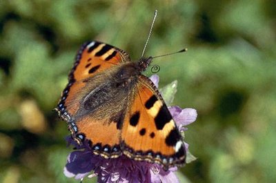
Petite tortue posée sur une fleur. - PNV - FOLLIET Patrick FaunaThe small tortoiseshell
The small tortoiseshell is the first butterfly to land on the flowers which are barely out of the snow. The caterpillars feed only on nettles. They can be seen on their leaves piled into bundles with their two yellow bands on their backs. The butterfly, on the other hand, is orange in colour, inlaid with ebony and hemmed with a ring of blue spots around the edge of the wings.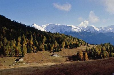
Chalets de l'Orgère et cembraie. - PNV - PERRIER Jacques  History
The Orgère valley
Orgère, where barley was grown. In past centuries, the need for pastures, hayfields and cultivated land on flat or slightly hilly areas forced man to deforest, even at high altitude. The right bank of the valley, presenting a gentler profile, was the most exploited. The rocks which clutter the plots are regularly placed in heaps, to form mounds of stones which still remain in the valley. Used during the summer, the valley was brought to life by about fifteen families and their little flock.