
Terraced path of Turra in Loza
VAL-CENIS
Terraced path of Turra in Loza
Easy
6h
13,4km
+1008m
-1008m
Loop
Embed this item to access it offline
The promontories that make up the Turra d´Aussois and the Croix de la Loza, for me, have always been the best spots to see birds of prey, such as eagles and bearded vultures who soar from these spots. Karine Moussiegt – National Park ranger
Description
Leave Sardières church car park. Take the path to the north-east of the village in the direction of the valley and stream of Villeneuve. Leave several trails starting on the left and gradually climb in to the forest to reach and cross the valley of Villeneuve in the direction of Loza. Cross the boundary of the heart of the National Park around 1,980 m in altitude and finish the climb by crossing the alpine pastures towards the Croix de la Loza. Then reach the GR5 and take the direction of Turra d´Aussois by staying on this terraced path. Under the Turra, leave the GR5 by taking one of two possible variations to go down to Aussois and the Fournette spring. From there, head in the direction of the Monolith then the village of Sardières.
- Departure : Sardières church car park
- Arrival : Sardières church car park
- Towns crossed : VAL-CENIS and AUSSOIS
Forecast
Altimetric profile
Recommandations
The route is long and crosses several other paths. It is therefore necessary to bring maps and prepare your journey well prior to leaving.
Is in the midst of the park
The national park is an unrestricted natural area but subjected to regulations which must be known by all visitors.
Information desks
Musée d'Archéologie, 73500 Sollières-Sardières
Transport
"Rail connection to Modane. Information: www.voyages-sncf.com
Then transport by coach to Sardière. Information: www.transavoie.com
Suggested hitchhiking organised in the Haute-Maurienne valley. Information: www.rezopouce.fr"
Then transport by coach to Sardière. Information: www.transavoie.com
Suggested hitchhiking organised in the Haute-Maurienne valley. Information: www.rezopouce.fr"
Access and parking
From Modane take the Route d’Aussois the continue towards Sollières-Sardières. The car park is located next to the church at the hamlet of Sardières.
Parking :
Parking de l'église à Sardières
10 points of interest
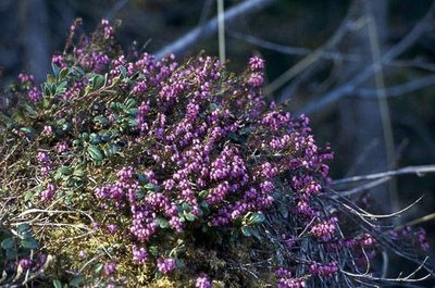
Bruyère carnée. - PNV - BENOÎT Philippe  Flora
FloraWinter heath
"The winter heath (Erica carnea) takes its name from its early blooming red or pink, ""flesh coloured” flowers (May-June). It is a protected plant in the Rhône-Alpes region and, although very rare throughout the rest of France, is common in Maurienne. On the Loza route, it reaches record altitudes in the last moors right under la Croix. In early summer, as soon as it has freshly snowed, your walk will take you through a real-life impressionist painting."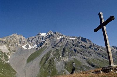
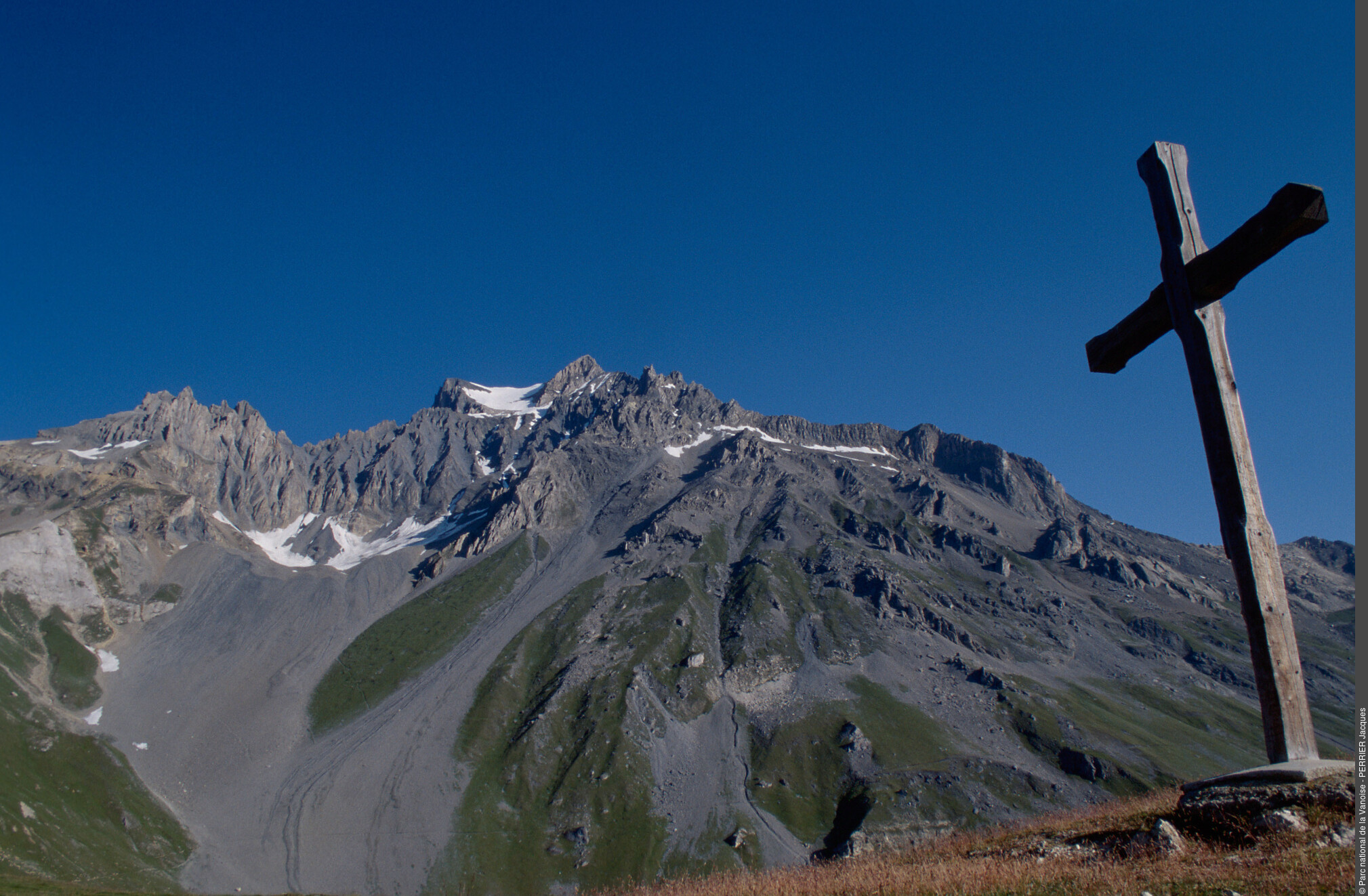
La croix de la Loza et vue sur la Dent Parrachée. - PNV - PERRIER Jacques  Viewpoint
Croix de la Loza
The Croix de La Loza culminates at 2,377 m in altitude at the summit of a perfectly rounded grassy dome. From there the hiker can enjoy a wide panorama since from this east-oriented prow, he will face the Upper Valley of Maurienne where there is a view of the valley line, from Lanslebourg to Bonneval-sur-Arc, bordered by impressive peaks. But the most majestic sight is towards the north-west. He can then see every detail of the south face of the Dent Parrachée (3,697 m) nearby. Next to the harmonious rock forms and colours, you will feel so small.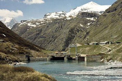
Prise d'eau (à vocation hydro-électrique) sur le Doron de Termignon. - PNV - VON CONTA Beatrix  Water
WaterEDF tunnel
At around 2,000 m in altitude, in the valley of Villeneuve, a straight-lined construction indicates the presence of an underground tunnel 16.8 km in length which pipes the waters of the Doron de Termignon from Entre-Deux-Eaux and along the way captures all the torrents of the southern slope of the Vanoise massif to discharge them into the Plan d´Aval dam in the neighbouring town of Aussois. Commissioned in August 1941, the water intake of the Doron de Termignon is one of the thousands that EDF has installed in the Alps.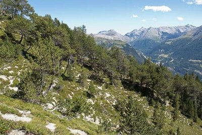
Boisement de pin à crochets et sous-bois de bruyère. - PNV - LACOSSE Pierre FloraAdret forest
The dry forests occupy an important place within the National Park, especially in the Maurienne valley, where the southern slopes of the Vanoise (adrets) are located. The species found within these forests are the Scots pine, spruce and mountain pine.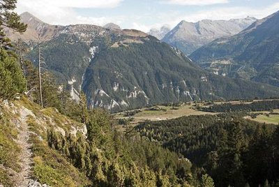
Combe de Villeneuve. - PNV - JOURDAN Jérémie FloraVegetation in the avalanche path
The valley of Villeneuve is a wild environment dominated by big rock bars upstream and funnel-shaped forms downstream. The vegetation, consisting of scrawny mountain pines, is evidence of the pressure exerted by avalanches.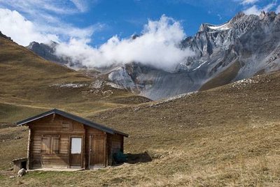
L'alpage de la Loza et la cabane du berger. - PNV - JOURDAN Jérémie  Small heritage
Alpage de la Loza
It is a herd of sheep from the village of Sollières which has its summer quarters on the alpine pasture of the Loza. Since the return of the wolf, a wooden chalet has been built providing shelter for the shepherd who stays there on a daily basis to ensure the safety of his flock. The Alpage de la Loza benefits from a contract between the farmer, the Chamber of Agriculture and the Park to lead agro-environmental measures conciliating pastoralism and the protection of species.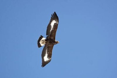
Aigle royal : juvénile de moins d'un an, en vol. - PNV - PLOYER Jean-Yves  Fauna
FaunaThe eagle
"It is not uncommon to see golden eagles on this route. The ingredients essential to the presence of this predator are all provided there. Good hunting grounds rich in prey and good lift for an excellent flight. The marmot unfortunately pays a heavy price given that it constitutes 80% of the eagle’s diet in summer. Chestnut brown in colour, with a 2.25 m wingspan, the golden eagle makes use of the slightest gusts of hot air and can often glide along on a single wingbeat for kilometres. In flight, its wingtips are well raised and its tail is fanned. To hunt it will accelerate near the relief and catch its prey by surprise at the turn of a natural obstacle. The bird of prey’s nest (often referred to as an ""eyrie"") is often located on the other side of the valley in a rocky bar at an altitude lower than the hunting ground so that the prey is easy to carry back by gravity."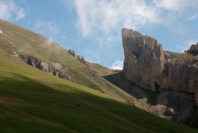
Alpages vers le Roc des Corneilles (visible à dr.). - PNV - LACOSSE Pierre  Geology
Roc des Corneilles
"Half way between Loza and Turra is the Roc des Corneilles, a characteristic sharp-edged cargneule rock located 200 m above the GR5. It is unique in the fact that it is crossed by a large crescent-shaped breccia giving it the nickname ""hollow moon"". From there, you have a beautiful view of the Rateau d´Aussois. If you feel ready, you can get to it by leaving the GR and following the grassy rump north of the 2,456 m point on the IGN map. The famous Crows could very well be in fact groups of alpine choughs, a bird typical of the high reliefs, gregarious in nature and acrobatic in flight."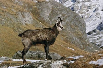
Jeune chamois, mâle, en pelage d'hiver. - PNV - BOUCHE Michel FaunaChamois
The trail on the GR 5 leads along a balcony dominated by large straight grassy slopes. From a fair distance, you can see the sheep and herds of chamois. These animals look like little dark spots on the almost vertical slopes but can be seen in much more detail with your binoculars: their heads are black around the eyes and white on the cheeks, thin black horns with hooked ends. The chamois is a cousin of the goat and the ibex. The kids are born at the end of May, beginning of June and it is not uncommon to see them in little groups having fun slipping and jumping on the last nevés.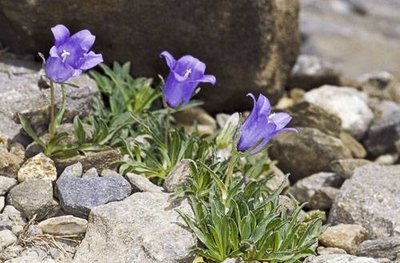
Campanule alpestre. - PNV - DENISE Cyril FloraCampanula alpestris
On the path descending from Turra, towards Aussois, keep your eyes open for this large purple-blue bell flower with bent hairy head, atop an inversely minuscule stem. It flowers in July - August. It is a campanula which likes the schistous and limestone screes. It is a rare and protected species in France.