
Glacier de la Martin
This hike on the vertiginous east face of Mont-Pourri, will lead you from the world of men, with the hamlet of Gurraz and Chevril dam up to the ""eternal"" kingdom of the glaciers, where only the ibex ventures.
"Description
From Chantel car park, follow the path which gœs to the left. Follow it for about 280 m, then continue on the trail leading off it to the first hairpin bend. Cross the Mont-Pourri stream with EDF water intake. The trail enters the shrub vegetation and meanders. Once out of the forest, you arrive at Crêt (chalet). Follow the path into the mountain pastures. Cross the Savinaz stream over the wide footbridge. Continue until Refuge de la Martin. From the refuge, head in the direction of “Glacier de la Savinaz 0h20” The trail ends in the midst of moutonnées and moraines rocks. To return, follow the path in the opposite way.
- Departure : Chantel car park, Hamlet of Gurraz, Villaroger
- Arrival : Chantel car park, Hamlet of Gurraz, Villaroger
- Towns crossed : VILLAROGER
Forecast
Altimetric profile
Recommandations
At the end of the trail, it is not recommended to venture further without being accompanied by a mountain professional (guide). In the summer, ice blocks can come loose from the glaciers without warning. Ÿou can take your dog with you, but only up to the Refuge de la Martin. Beyond the refuge, you enter the heart of the National Park. Please ensure you respect the park’s special regulations.
Information desks
Tourist Information Office - Tignes
Maison de Tignes-le-lac BP 51, 73321 Tignes
Access and parking
Parking :
10 points of interest
Arrivée perturbation venue d'est, avec débordement frontalier de nuages sur les cols de la Traversette et du Saint-Bernard. - PNV - BALAIS Christian  Viewpoint
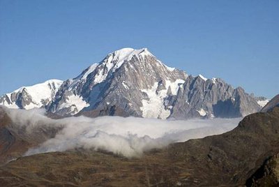
Balcony overlooking Mont Blanc
To the north, beyond the summits bordering the right bank of the valley of Col du Petit St Bernard, rises an imposing glacial massif. At a height of 4,810metres, Mont Blanc, the highest mountain in the Alps, looms over the steep Italian slope. Glaciers and rock walls block the horizon in an awe-inspiring, wild landscape which proves difficult to access. It is the domain of the exceedingly high mountain.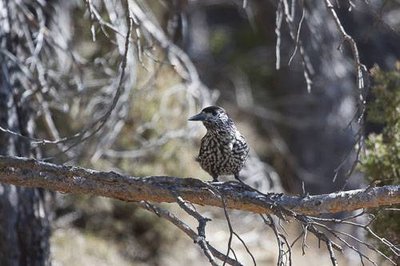
Casse-noix moucheté. - PNV - PLOYER Jean-Yves  Fauna
FaunaThe spotted nutcracker, guest of the conifer forests.
Amid two trees, an enormous figure passes by discreetly, with a sharp beak, mottled brown plumage and white-striped tail. Then, from the top of a spruce, the spotted nutcracker launches its discordant, raspy cry. This sedentary corvid lives in the coniferous forests where it feeds mainly on coniferous seeds. In the autumn it will bury its provisions although will sometimes forget them.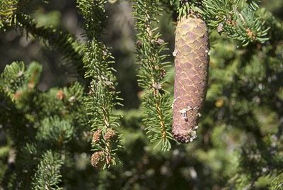
Cône d'épicéa avec perles de résines. - PNV - BALAIS Christian  Flora
FloraBarbs and woodpeckers
"The spruce flourishes on the ubac slope, dominating the hardwoods of the mountain zone. Often wrongly called ""fir"", it is easily identified by its cones which hang under the branches, with needles laid out around the twigs, prickly to the touch, while the tree is supple and soft under the hand. The trunk of the spruce is sometimes bored into by woodpeckers, in search of larvae or to house their brood."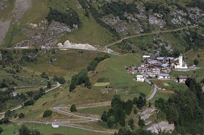
Le village de la Gurraz et ses environs. Vue vers l'ouest. - PNV - BALAIS Christian  Architecture
The hamlet of Gurraz
Under the protection of Saint-Roch and its church, the hamlet of La Gurraz nestles behind an old moraine, sheltered from the dreadful avalanches that sometimes hurtle down the north slope of the Mont-Pourri massif, causing windows and chimneys to rattle. In 1990, the village was cut off from the world for four days. Narrow alleys, stone houses with wooden balconies opening on to the hay barns, bread oven… infuse this alpine mountain village with authenticity and character.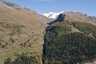
Le Nant Cruet. Au fd., l'Aiguile de la Petite Sassière et, à dr., l'Aiguille de la Grande Sassière. - PNV - MÉLÉ Stéphane ViewpointThe panorama over the Nantcruet valley
From the cross looking eastwards, you can see the very steep-sided stream of the Nant Cruet, with the Aiguille de la Grande Sassière at the bottom of the valley, culminating at 3,747 m. The left bank of the torrent on the cold and humid ubac slope (north-facing side), is little exploited by man, which has allowed the forest to establish. By contrast, the right bank, located on the adret slope, testifies to the strong agricultural activity characterised by numerous hamlets, hay meadows and mountain pastures.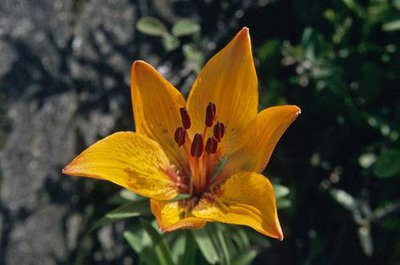
Lis orangé. - PNV - BALAIS Christian FloraThe orange lily
While hiking on this part of the trail from June to July, scour the cliffs upstream and your eye will be drawn to the flamboyant colour of the orange lily. Ÿou will easily recognise it with its long angular stem more than 25 cm high, adorned with one or more bright orange flowers at the top. Present up to 2,200 m in altitude, it is particularly fond of these rocky terraces on limestone soil well exposed to the sun.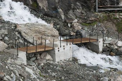
Passerelle des Balmettes mise en place pour la 1e fois en juin 2010. Arr.-pl. l'ancienne passerelle qui n'est plus utilisée. - PNV - MÉLÉ Stéphane  Small heritage
The Passerelle des Balmettes
Composed of 4 wooden structures of approximately 600 to 700 kg, this footbridge is dismantled every autumn by helicopter and assembled at the end of spring. It provides hikers with access to the heart of the Vanoise National Park by allowing them to safely cross the Savinaz stream which is impassable in times of high flows. The footbridge was also designed to allow access to the farmer’s pastures and his herd of heifers.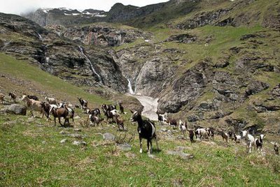
Troupeau de chèvres pâturant dans les alpages de Villaroger, en rive dr. du Ruisseau de la Savinaz. - PNV - MÉLÉ Stéphane  Pastoralism
The alpine pastures of Savinaz
"Agriculture has been declining for several decades in the municipality of Villaroger because the sloping terrains are not favourable to mechanisation. The alpine meadows of Trousse (called the ""mauvais prés"") and their upper part, which are dependent on the mountain pasture of Martin, illustrate this reality. Where once hay was formerly used, agriculture is still maintained today with herds of goats and heifers which make it possible to prevent these alpine pastures from being filled with green alder."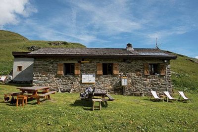
Le refuge PNV de la Martin et ses aménagements extérieurs. Commune de Villaroger. - PNV - BUCZEK Jessica  Refuge
The Refuge de la Martin
This shelter, kept from the end of June to the beginning of September (providing food and accommodation), remains open for self-catering for the rest of the year. Before becoming the property of the Vanoise National Park in 1972, it was a former alpine chalet which was built from materials extracted on site starting in 1932. It was home to the Alpage de la Martin for a period of thirty years during which Beaufort, Sérac and butter were produced.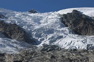
Glacier de la Savinaz. - PNV - MÉLÉ Stéphane  Glacier
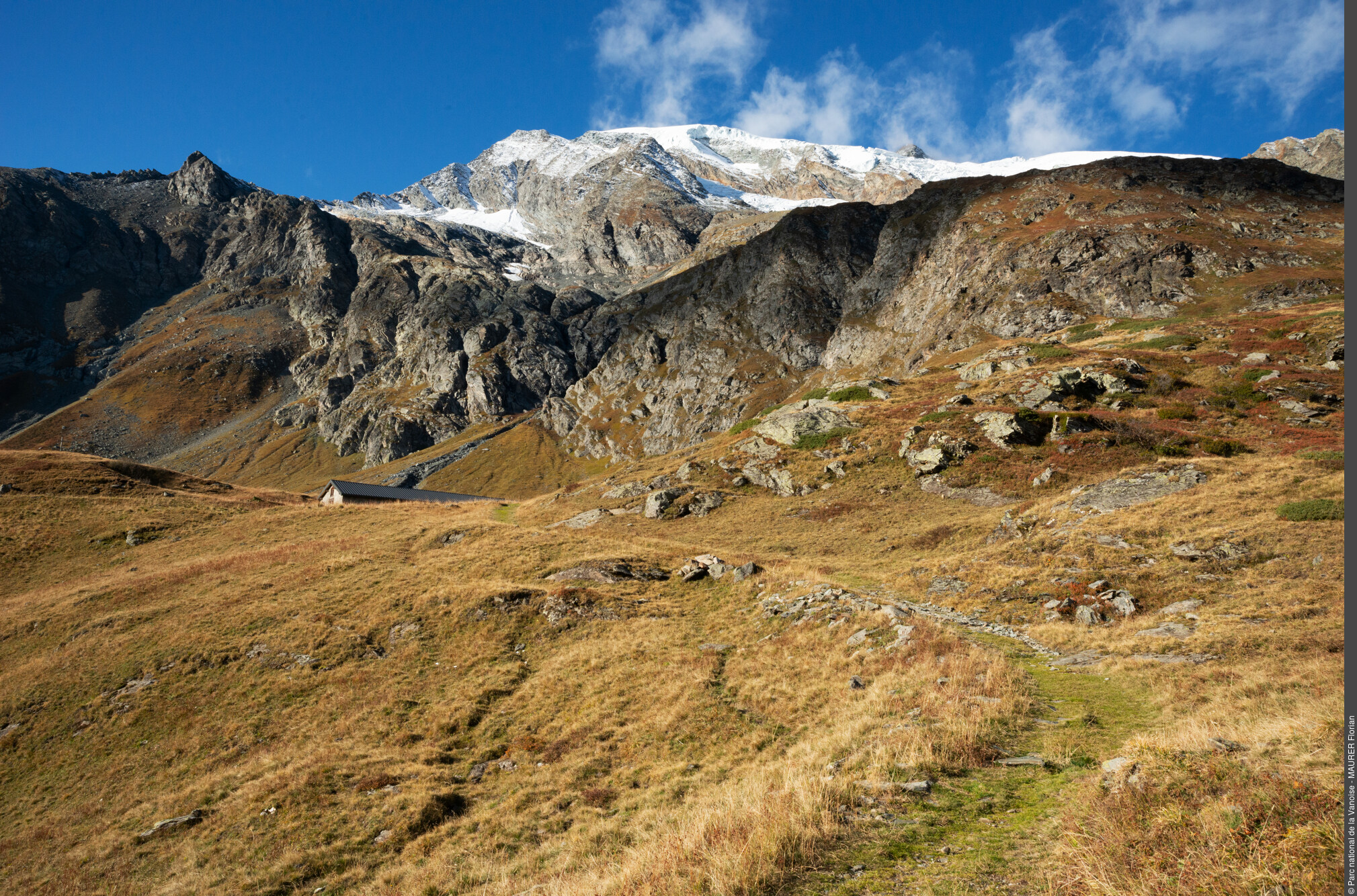
The glaciers of Martin and Savinaz
The end of this hike offers an exceptional panoramic view over the glaciers of Martin and Savinaz. Access road to the Dôme de la Sache (3,601 m in altitude), this itinerary has been increasingly abandoned by mountaineers due to the major decline of glaciers, linked to global warming and furthering the opening of crevices and serac falls. In the early 1980s, their glacial tongues descended to the trail where you now stand.