
Tour of the Pointe du Chardonnet
TIGNES
Tour of the Pointe du Chardonnet
Easy
8h
12,7km
+735m
-783m
Loop
Embed this item to access it offline
Although some days the ski lifts are more important for me, during the climb from Tignes, I will never tire of the joy in rediscovering the valley of Peisey-Nancroix from the Col du Palet. Like the God Janus, this route takes place over two different faces of the mountain, one which is natural and the other which is equipped with amenities. Thierry Arsac, Vanoise National Park ranger
Description
From the wooden terrace of the Maison de Tignes (tourist information office), follow the building to the right, get back on to the trail that starts to the right of the Palafour ski lift. Join a track which you follow on your left for about 150 m. The trail leaves the track on the left. After about 600 m, the trail passes between 2 mountain bike trails. Follow the route in to the middle. After 250 m of gradient, take the vehicle track on the left. It will bring you to the Chardonnet Lakes. Continue along the track that leaves to the right between the two lakes, until you reach the GR®5. Follow the GR®5 to the Refuge du Col du Palet via the pass of the same name. From the refuge, follow the GR®5 until the next fork in the road, 50 m after the Lac du Grattaleu. Take the trail on the right in the direction of “Col de la Tourne 0h50”. About 1 km uphill where the path forks again, take the trail on the right. From the Col de la Tourne, follow the trail until you reach the vehicle track 50 m before the Beau stream. Continue on the track for 80 m, turn right and walk for another 600 m. Join the trail that brought you from the Maison de Tignes. Follow the trail downhill.
- Departure : Maison de Tignes, Tignes Le Lavachet
- Arrival : Maison de Tignes, Tignes Le Lavachet
- Towns crossed : TIGNES and PEISEY-NANCROIX
Forecast
Altimetric profile
Recommandations
Part of the route takes place in the Tignes-Champagny nature reserve. Please respect the park’s special regulations that may differ from the National Park regulations.
Is in the midst of the park
The national park is an unrestricted natural area but subjected to regulations which must be known by all visitors.
Information desks
Tourist Information Office - Tignes
Maison de Tignes-le-lac BP 51, 73321 Tignes
Vanoise Information Desk - Val d'Isère
Immeuble le Thovex, Office de tourisme, 73150 Val-d'Isère
Transport
Rail connection to Bourg-Saint-Maurice. Information: www.voyages-sncf.com
Then transport by coach to the administrative centres of Tignes or Val d´Isère. Information:www.transavoie.com
Access and parking
"RD 902 then RD 87a, in the direction of ""Tignes"""
Parking :
Covered car park of Lake 1 or 2, Tignes-le-Lac
More information
6 points of interest

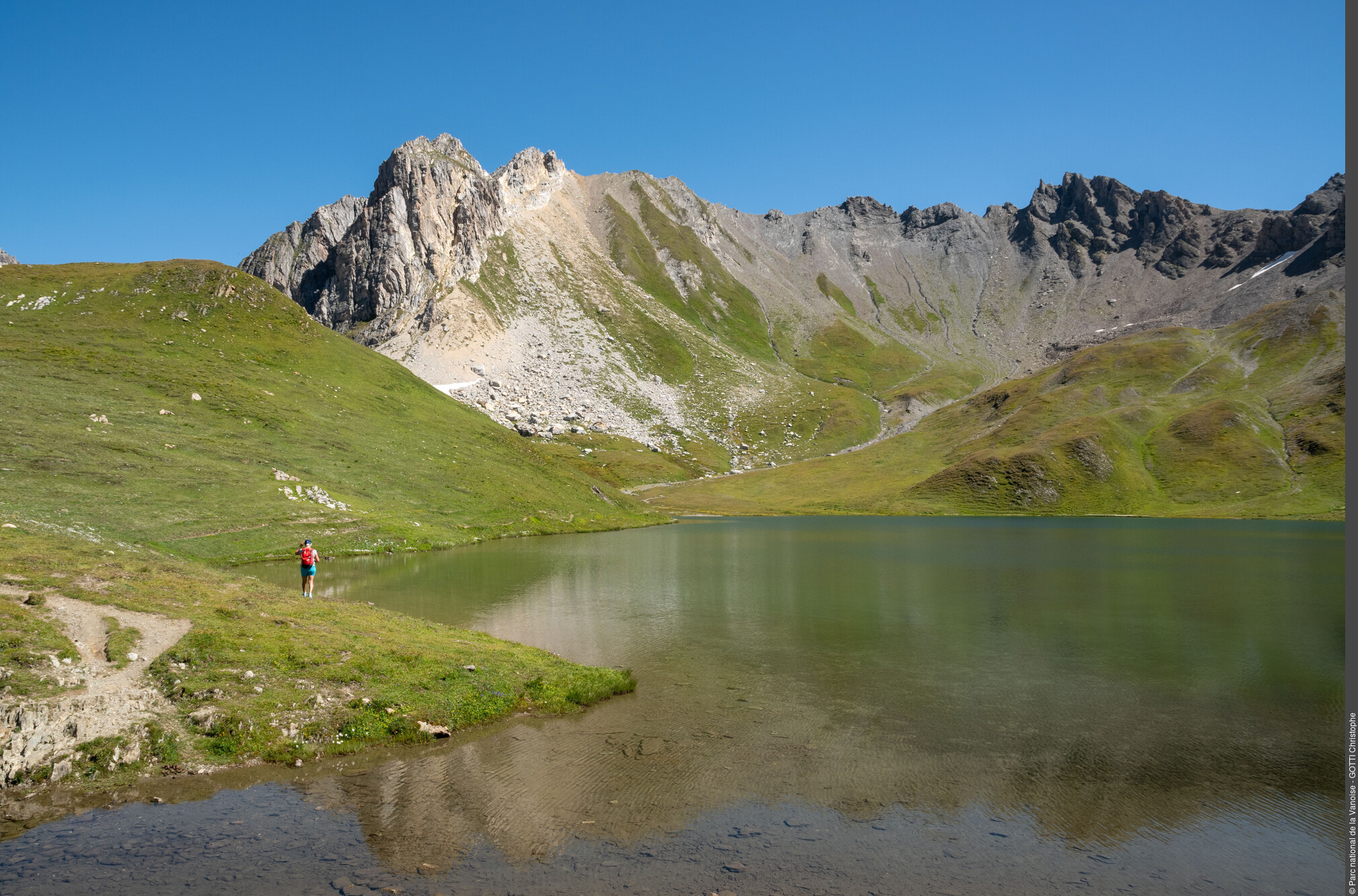
Lacs du Chardonnet - Andy Parant  Water
WaterChardonnet Lakes
Their cold clear waters served as a setting for the film "The Big Blue"!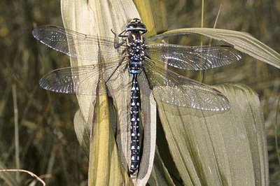
Sur la tourbière, un individu adulte mâle d'aeschne des joncs. (PNV PO, APPB du Plan de l'Homme). - PNV - STORCK Frantz  Fauna
FaunaThe common hawker
Thanks to a stop near the Lac du Chardonnet, you may be able to see the common hawker flitting about. The exclusively aquatic larva of this dragonfly takes nearly 3 years to reach maturity. It emerges from the water and sheds its skin to become a flying adult whose short life (a few weeks) is devoted to reproduction. With nearly 100 species, France has the greatest wealth of dragonflies in Europe.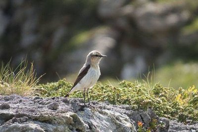
Traquet motteux : femelle en alerte sur son territoire. - PNV - POULET Laetitia FaunaThe wheatear
Among the birds that inhabit the alpine meadows, the wheatear is recognised in flight by the broad inverted T against a white background which colours the end of the tail. This far from shy insectivore only honours us with its presence in summer before flying back to its grounds in Africa in late summer.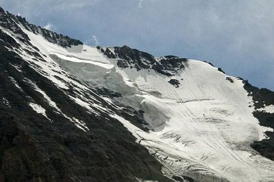
Vue sur le Couloir des Italiens en face N de la Grande Casse. - PNV - FOLLIET Patrick  Viewpoint
The north face of the Grande Casse
At the Col du Palet, you enter the restricted zone of the Vanoise National Park. Here, the view over the north face of the Grande Casse is impressive with its hanging glacier. Highest point of the Vanoise massif (3,855 m in altitude), this 900 m dark face is comprised of limestone derived from marine deposits. To its left, the summit of Grande-Motte and to its right, the Aiguille de l´Épena.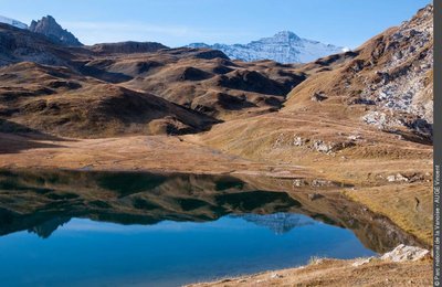
Le lac du Grattaleu - Vincent Augé, PNV  Lake
LakeLac de Grattaleu
Lac de Grattaleu is one of the 130 high-altitude lakes of the Vanoise massif. Trapped in the ice for nearly six months per year, only certain invertebrate species survive in these conditions. The lake surroundings are a spectacle of cotton grass. These plants with white bristles form a cottony carpet and although located at 2,500 m in altitude, the mallard ducks enjoy stopping here.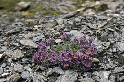
Linaire des Alpes. - PNV - BALAIS Christian  Flora
FloraThe linaria alpina
The linaria alpina, a scree plant, “dazzles” you with its violet flowers and orange heart. Its long, hard root allows it to anchor itself in to this unstable environment. The flowers of this honey plant attract honey bees and bumblebees thanks to their rich nectar which accumulates at the bottom of the spur.