
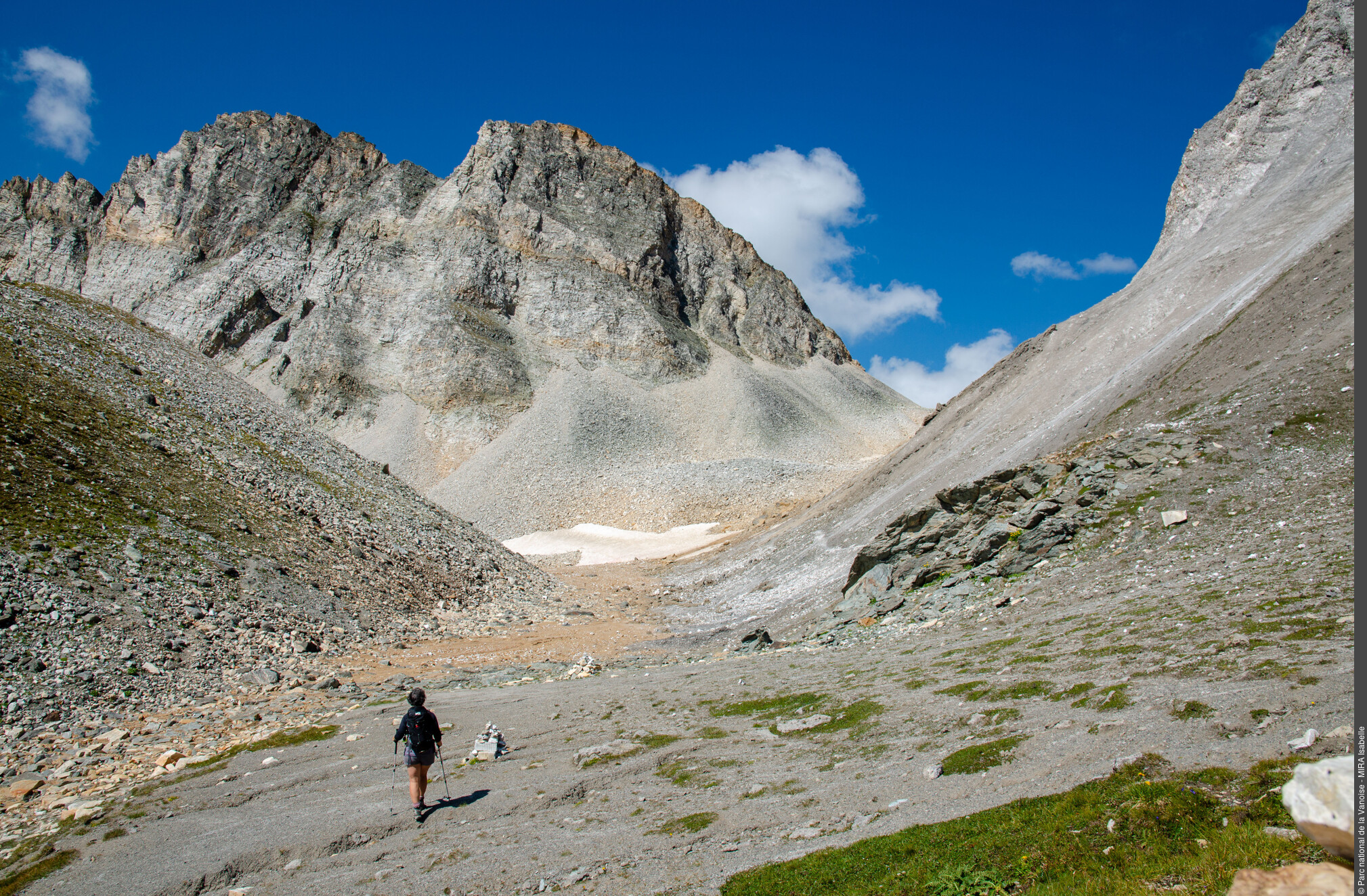
Col du Soufre
Description
- Departure : Méribel-Mottaret car park, Les Allues
- Arrival : Méribel-Mottaret car park, Les Allues
- Towns crossed : LES ALLUES and PRALOGNAN-LA-VANOISE
Forecast
Altimetric profile
Sensitive areas
- Impacted practices:
- Land
- Sensitivity periods:
- JanFebMarAprMayNovDec
- Contact:
Nicolas Gomez - conservateur de la réserve naturelle nationale de Tuéda - nicolas.gomez@vanoise-parcnational.fr
04 79 08 60 81 ou 04 79 01 04 75
- Impacted practices:
- Land
- Sensitivity periods:
- JanFebMarAprMayNovDec
- Contact:
- Nicolas Gomez - conservateur de la réserve naturelle nationale de Tuéda - nicolas.gomez@vanoise-parcnational.fr
04 79 08 60 81 ou 04 79 01 04 75
- Impacted practices:
- Land
- Sensitivity periods:
- JanFebMarAprMayNovDec
- Contact:
Nicolas Gomez - conservateur de la réserve naturelle nationale de Tuéda - nicolas.gomez@vanoise-parcnational.fr
04 79 08 60 81 ou 04 79 01 04 75
Alpine ibex - winter
- Impacted practices:
- Aerial, Land, Vertical
- Sensitivity periods:
- JanFebMarDec
- Contact:
Parc national de la Vanoise - Nicolas Gomez -
nicolas.gomez@vanoise-parcnational.fr
Alpine ibex - winter
- Impacted practices:
- Aerial, Land, Vertical
- Sensitivity periods:
- JanFebMarDec
- Contact:
Parc national de la Vanoise - Nicolas Gomez -
nicolas.gomez@vanoise-parcnational.fr
Recommandations
Information desks
Maison de la Réserve de Tueda, Mottaret, Lac de Tuéda, 73550 Méribel
Transport
Access and parking
Parking :
Accessibility
- Emergency number :
- 114
10 points of interest
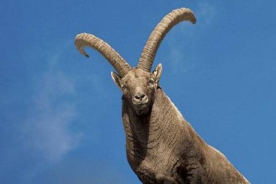
Bouquetin mâle : individu âgé vraisemblablement de plus de 8 ans. (RN du Plan de Tuéda). - PNV - IMBERDIS Ludovic  Glacier
Ibex in Marseille?
Imagine 20,000 years ago, Lyon, Chambéry and Grenoble are drowned in an ocean of ice. Corsica and Great Britain are no longer islands because the level of the oceans is 100 m lower, and our ancestors hunt ibex and the European bison around Marseilles. Here, ice more than 1,000 m thick crushes you. Over the previous 2 million years, the periods of advancement and glacial retreat alternate every 100,000 years to the rhythm of the changing climate.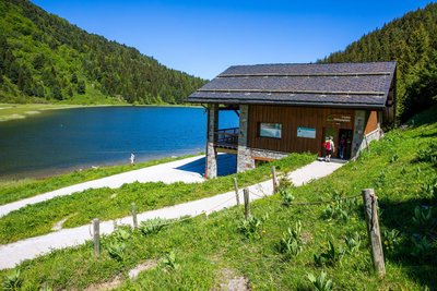
Maison de la Réserve naturelle du plan de Tueda - Sylvain Aymoz  Flora
FloraPlan de Tueda National Nature Reserve Centre
The National Nature Reserve was created in 1990 and is managed by Vanoise National Park. Plan de Tueda National Nature Reserve is located downstream of Vanoise National Park in the municipality of Les Allues. It extends from Lake Tueda all the way to the Gébroulaz glacier, encompassing both riverbanks of the Doron des Allues: in total there are 1,100 protected hectares of outstanding natural scenery to explore (and respect)! You can find out all about the secrets of the reserve’s biodiversity and the Swiss pine and its forest through a free exhibition and a range of activities all year round. Your host at Vanoise National Park can also answer any questions about the park, forthcoming events and walks in the area if you’d like to extend your outing (you can book guided outings with the Park’s warden-instructors). There is also a shop, where you can pick up a little souvenir of the Park to take home with you! And if you still want to find out more, head to the nearby glaciological trail for a fuller understanding of the landscape and the valley’s history. In the summer only, there’s also a botany trail to enjoy and tours of the reserve are organised by the warden.
The centre is located in the Nature Reserve, so please follow the regulations. Dogs are not allowed in the Reserve, and may only be taken around the lake on a lead.
Open in the summer.
Maison de la Réserve de Tueda - Mottaret
Meribel Mottaret - Lac de Tuéda
73550 Les AlluesTel.: +33 (0)4 79 01 04 75
http://www.vanoise-parcnational.fr/
Free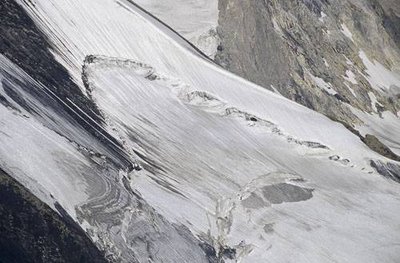
Rimaye du Glacier de Prémou, Champagny en Vanoise. - PNV - BENOIT Philippe GlacierA glacier! How does it work?
The snow falls and then compacts by the successive accumulation of layers. It becomes névé when it moves from a density of 100g/l to 500g/l. Depending on the altitude and its exposure to the sun, the névé stops melting in summer. The accumulation of these successive névés causes the formation of ice due to compression. Its density is then 900 g / l. Under the effect of the slope and its own weight, the glacial tongue begins to slide. The crevice between the névé and the glacier is called the “bergschrund”.
Pin cembro à Pré Petit-Jean. Vue vers l'Aiguille du Fruit. Vue vers E. (RN du Plan de Tuéda). - PNV - IMBERDIS Ludovic  Fauna
FaunaA reserve for a bird and a tree
Since its creation in 1990, the Plan de Tuéda Nature Reserve has focused its preservation work on the cembro pine forest and the black grouse. This bird is an arctic-alpine relict Its history is intertwined with that of the glaciers. During the last ice age, our galliform was pushed back to Southern Europe by the advancing glaciers and in their retreat, some chose to ascend in altitude while others went back up to Northern Europe. As a consequence, these populations were separated. Glacier
A small plane cutter!
"The glaciers behave like very large ""planes"". In a period of advance, they tear blocks of rock out of the mountain and crush them. Depending on the hardness of the rocks, this erosion happens relatively quickly. There is therefore a “rock bar” downstream of each glacial plateau. The slopes that you’ve just passed between the plateau of Plan de Tuéda and that of the Fruit are a fine example of this."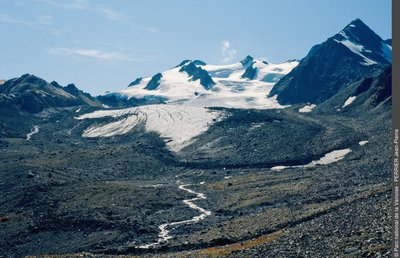
Jean-Pierre Perrier GlacierBack and forth!
The glacier deposits and moves all rock debris that it tears from the mountain to the rhythm of these advances and subsequent retreats. These mounds are called “lateral moraines” when they are deposited on the sides of the glacier and “frontal moraines” when they are on the former glacial front. Behind the rock bars and moraines, glacial lakes can form. They generally disappear as a result of the filling or splitting of the dykes created by the moraines.- Glacier
Living memories
Ÿou will find yourself on the last “rock bar” cleared by the Gébroulaz glacier. Towards 1730, the “Sarde map” (land registry of the kingdom of Piedmont-Sardinia) identifies the glacial threshold at the foot of this “rock bar”. This glacier is followed between 1907 and 1965 by the Eaux et Forêts (Forestry and Water), and from 1991 by the CNRS (French National Centre for Scientific Research). It is part of a network of 9 worldwide glaciers (5 Alpine, 2 Andean and 2 Antarctic) used for the long-term monitoring of glacial and meteorological data. 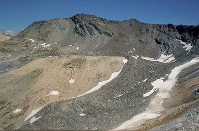
Au Col du Grand Infernet : glacier rocheux et nunatak visible entre deux branches. Les Allues. - PNV - PERRIER Jacques GlacierWhite, black and fossil.
"There are 3 types of continental glaciers: the ""white"" glaciers, such as Gébroulaz, where the ice is visible year-round and flows along the slope. The ""black"" glaciers, such as the one in the Col du Grand Infernet, are covered with stones and continue to flow. And finally the ""fossil"" glaciers, which subsist only in the form of traces of pebbles that take a concentric form (small waves) and where the ice has disappeared completely. The latter are immobile. This is the case below the Col du Fruit in this valley!"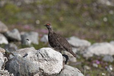
Lagopède alpin mâle en plumage estival. - PNV - DELORME Michaël FaunaBefore the “Chasseurs Alpins” (Alpine Hunters)
Wearing white camouflage was not invented by the Alpine troops. This discovery is to be attributed both to the mountain hare and another arctic-alpine relict, the rock ptarmigan (Lagopus mutus). This cousin of the black grouse trades its summer grey-brown plumage for an entirely white camouflage in winter. And as if this adaptation to the snowy environment were not enough, the bird has also evolved to have furry boots! Its entire claw up to the tip is feathered&hellip, you guessed it, in white.- Glacier
Shrinking away.
"Whereas glacier advance is known during the ""Little Ice Age"" (1600-1850), their retreat in the 150 years that followed is no longer in doubt (example: surface of Gébroulaz in 1965: 420 ha and in 2009: 330 ha). Recent monitoring has given surprising results. The upper part of the glacier (above 3,100 m in altitude) has thickened by 20 metres! Explanation: the glacier passes through a rocky narrowing which compresses it laterally and causes it to swell artificially."